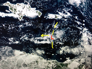
The one way out in the Atlantic remains disorganized, although the first cluster appears better organized. Remember that one as I'll get back to it. The weak wave over the eastern Caribbean has no storms with it so far. The GFS model continues to blow that up into a storm early next week bringing it into the Gulf.
The bottom view is the Gulf right now. There is a cluster of storms in the Bay of Campeche and the old rain boundary across the northern Gulf. Here's what the GFS does with the wave in the Caribbean for late next week.
The top view is valid for NEXT Friday afternoon with the bottom for Monday morning Sept.5th. Do you believe it that far out? Why? It's been doing that all season. Does the Euro agree?
Absolutely not. It has nothing in the Gulf in the same time frames, but does have a hurricane over the Bahamas. Bottom line, until we have something to track, all these model runs contribute to increased anxiety when there may not ever be a need. Sure the Tropics are likely to get active but this weekend we have nothing to worry about.
The above normal clouds and showers may make this one of the cooler Augusts on record. No 90+, no complaints here. Enjoy your weekend and the Saints tonight on FOX 8. Who Dat!


No comments:
Post a Comment