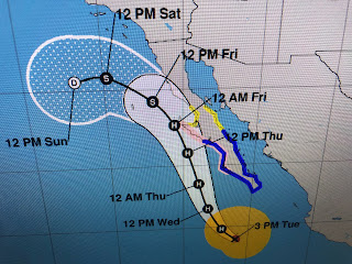
That big heat dome over the west will prevent Kay from bringing any relief. Over the Atlantic, we still have Hurricane Danielle & Tropical Storm Earl to track with more to come off of Africa.
The waves coming off of Africa will be the ones to watch as models indicate they will stay at lower latitudes moving farther to the west. Way too soon to know if we need to be concerned.
The Caribbean & the Gulf are quiet with a lingering moisture boundary across the NW Gulf. I see no signs of any development as this boundary awaits an upper disturbance back to the NW.
I;ve drawn the feature on the satellite view with the graphics showing the upper air pattern beginning with today, then valid for Thursday, then Friday, then Saturday and finally next Monday. Note the western heat dome is fattened as the upper westerlies sink southward. An upper low will park itself over the Great Lakes by Monday and that should bring down drier air over us. Don't look for any real cooling, but the lower dew points should mean cooler at night.
The real cooler air is still a long way north up in Canada where 40s & 50s bring out the sweaters & jackets.
Today's clouds produce only a few sprinkles, but they kept our highs in the mid 89s.


No comments:
Post a Comment