The good news is all systems have stayed away from any land areas so far. Earl's satellite appearance indicates it is gaining strength as the color IR now has a circular burst closer to the center.
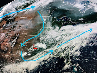
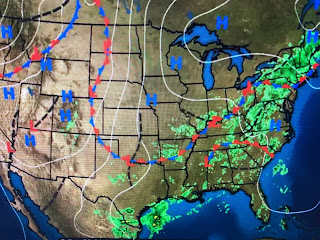
Closer to home, the Caribbean is quiet while a boundary remains over the northern Gulf coast. What we need to pay attention to later this week is for something spinning up along that boundary.
We have an upper low that was over Missouri yesterday and is sinking into northern Texas today. Models indicate that low will "cut off" from the main flow just to our west by Thursday. How it interacts with the current moisture boundary will be the key. Right now my thinking is for something to spin up south of our coast and head to the Florida beaches by the weekend. Look at the wave of moisture on radar over the western Gulf.
It's not associated with any surface front so let's see how it interacts with the approaching upper low.
That moisture boundary goes all the way into New England and is causing widespread flooding closing interstate 95 outside of Providence. The heat dome continues over the west where many fires are sending smoke plumes hundreds of miles to the east.
Dryness is not a problem down South as many days of on/off showers will linger into the weekend.
The clouds and showers are keeping us less hot as today's high stopped at 87.
Rain chances will stay above normal most of this week. Remember, 60% chance does NOT mean it will rain 60% of the time. It refers to coverage area and there should be many dry hours between showers. Hope you had a relaxing Labor Day and not it's time to start thinking Saints! Stay tuned!


No comments:
Post a Comment