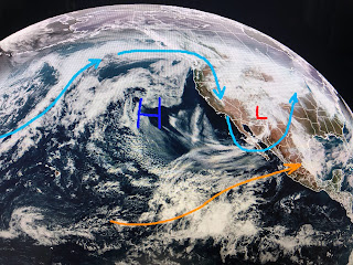
The "Atmospheric Rivers" that have drenched the West Coast for weeks, has been turned off as an upper ridge forms off the West Coast. The new storm track drops out of Canada down to the Rio Grande and then heads towards the Northeast, The severe potential develops where there is a "split" in the upper winds/jet streams between the northern & southern flows. That split enhances lift.
Right now, that split is over the Rockies (green circle) triggering more snow for them. Since the upper low over Arizona is much farther south than the low last week, the split in the jet streams is more likely to be closer to us.
As that disturbance taps into low level moisture (green outline), there should be widespread showers & storms develop Tuesday afternoon into early Wednesday. The exact location of that upper split will determine who will get the worst, most severe weather. Make sure your FOX 8 Weather App is updated with the alerts turned on. Here's the timing.
IF the models are correct, most of Tuesday during the day will be dry with increasing rain chances after 3 PM. Right now, it appears the greatest danger for strong storms comes after dark and before midnight. Remember, the driver of storms during the Winter (when the sun angle is low) is not daytime heating, but the upper splitting of the jet streams.
As Hannah showed at noon on FOX 8, there will be some strong winds gusts to 50+ and that could cause power outages. The heaviest rains are predicted to be over areas to our west, but that could change. We need to stay alert beginning after 3 PM tomorrow.
In the short term, let's enjoy the quiet as the surface high is drifting towards the eastern states. We'll see way more clouds tomorrow along with higher temps & humidity.
One factor limiting the heavy rain & severe threats could be low dew points/dry air. That will change during the day on Tuesday as winds return off the Gulf.
It will be colder behind the front, but it's not an Arctic Blast. So let's recap.
The latest model run tells us the severe Potential will be with the line of storms arriving between 10 PM and passing after midnight. Most of daylight Tuesday will be fine. Stay tuned!


No comments:
Post a Comment