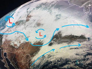
As the upper low lifts to the NE, we'll see a dry spell Sunday afternoon into Tuesday before another upper disturbance approaches. Too soon to know if that system will bring us a severe threat Tuesday evening into Wednesday.
The top view is the satellite view with the upper flow, the middle being this afternoon's position of that low with the bottom valid for Tuesday morning. Note the Tuesday low is farther to the south.
All in all, for late January the weather is pretty timid. There is no Arctic air in the lower 48 and the snowstorm over the Plains is not "historical". It's just basic January for most of the country.
We may see a bounce in the temps ahead of next Tuesday's disturbance, otherwise sweaters and jackets will be needed next week. Finally,,,
The air up in northern Canada is seasonally cold (25-35 below). Models do indicate a Polar Vortex will drop down into the Great Lakes The following Tuesday, 10 days from now. IF the Vortex keeps diving southward, we need to pay attention during the first week in February. However, right now the model is retreating the Vortex back to the NE and NOT down to the East coast. Snow geeks, don't give up hope yet as that's 10 days out and lots could change. Stay tuned!


No comments:
Post a Comment