Note how the Caribbean is predicted to be below normal. I'll start wide and focus tighter on the active Atlantic.
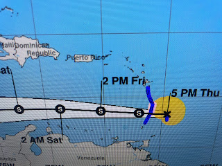
There is a system just coming off of Africa that NHC seems not interested in yet. The orange circle is T.D. # 4 with the red circle being T.S. Bret. TD 4 actually looks better that Bret on satellite loops. In fact, there are no T-Storms near the center of Bret, which usually is a dead give away that the system is struggling.
The track takes Bret through the Islands tonight and out into the Caribbean gradually weakening & dissipating. TD 4 should be named later tonight, but it's heading out into the Atlantic & is not expected to become a hurricane as it passes well north of the Virgin islands. finally, there is a cluster of clouds over the western Caribbean, but NHC doesn't mention it in their discussion/outlook.
One thing that hasn't happened this June so far is the westward building of the Atlantic Ridge/Bermuda High across the SE & Gulf. Instead we have seen a persistent East Coast upper trough that has cut off from the main flow. There are several lows with spokes of energy (black lines) rotating around the circulation. with some folks getting swamped while others get little.
One thing that is apparent is the upper & surface heat dome has retreated back into Texas & Mexico. Also, dew points are lower over us making us feel slightly less hot.
Our coastal locations got hammered yesterday and they're getting bashed again today. You can see the cooling relief from those storms on the temperature map.
A look at the 7 day indicates the only cooling relief will come if you're lucky enough to get a PM storm. Under the current pattern, we have seen large hail (golf ball) which is rare for us. So respect the heat & pay attention to these strong storms as there is always the potential for damaging winds, deadly lightning & large hail with decreasing chances later this weekend as the upper high builds back over us from the west. Stay tuned!


No comments:
Post a Comment