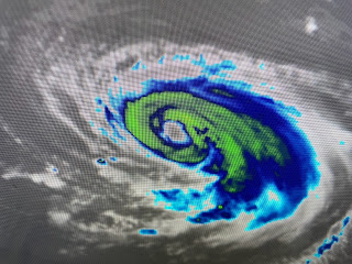
Sure looks like a hurricane in structure with a well defined eye, but notice the lack of any cold (red/orange colors) on the IR loop. Compare that to the storms approaching us from the north that indicate way more intensity. The thing I love about Don and the other three storms this year is what I found in the NHC advisory.
Keep them away from any landfall (Bret did move through the Islands) and we won't care if there are 40 storms this year. Hurricane Don moved over the warmer waters of the Gulf stream off the East coast and is now heading into much cooler waters. Note the loop he performed out in the middle of the ocean. The rest of the Atlantic is staying quiet due to Saharan Dust.
Invest 95 L is way east of the Islands and has lost most of its structure from yesterday. There are several ill defined swirls but the color loop finds no storms. Why?
Just like the increased wind shear from El Nino is our friend, so too the Saharan Air layer (SAL) that will last well into next week. Keep the dust coming!
The upper heat dome has shifted over the western states with another East coast trough coming down over the Great Lakes. It is driving down a weak frontal boundary that has triggered strong storms across the South. Dew points are in the 50s & 60s north of the boundary.
Finally, as a reminder, the International Grand Isle Tarpon Rodeo kicks off next Thursday through Saturday. I am again honored to be the MC for the awards ceremony Saturday night. New this year is a $10,000 cash prize awarded to anyone who registers for the Rodeo.
Just click on www.tarponrodeo.org and go to home page. Cost you $55 to register to fish for 3 days and you could win trophies for big fish in over 20 categories. But the best news is, you don't have to fish to win the grand prize of $10,000. Just register and I could be calling your name on Saturday night
My Colorado son sent me this graphic from ABC News's World News tonight on Friday. What do you see that jumps out at you right away? Actual air temps? Color of the map And some of you don't think there is an agenda that is being forced down our throats? I'll discuss more on this tomorrow. Stay tuned!


No comments:
Post a Comment