Thursday, August 31, 2023

Hurricane Idalia, After Further Review...

I love to watch FOX 8 Sports on Monday after a Saint's game where Sean Fazende reviews what plays worked and what didn't.  Here's my take on reviewing Idalia.   As I mentioned yesterday, NHC did a terrific job on the forecast track.  Several of you have already mentioned not so good on the intensity.   Originally they called for a Cat One at landfall and it ended up being a Cat. 3.  But was it?  NHC claims at landfall it had SUSTAINED  winds of 125 mph.  But all the "ground truth" data I've seen was much less.  In fact, Perry, Florida, only 7 miles inland and in the centerline track eyewall, reported maximum wind GUSTS of 85 mph.  Huh?  How could that be?  My guess is the intensity of Idalia was too high.  Insurance estimates are projecting damages of $12-15 billion.  That doesn't even crack the top ten costliest.  Idalia was no Ida, Ian or even Charley.


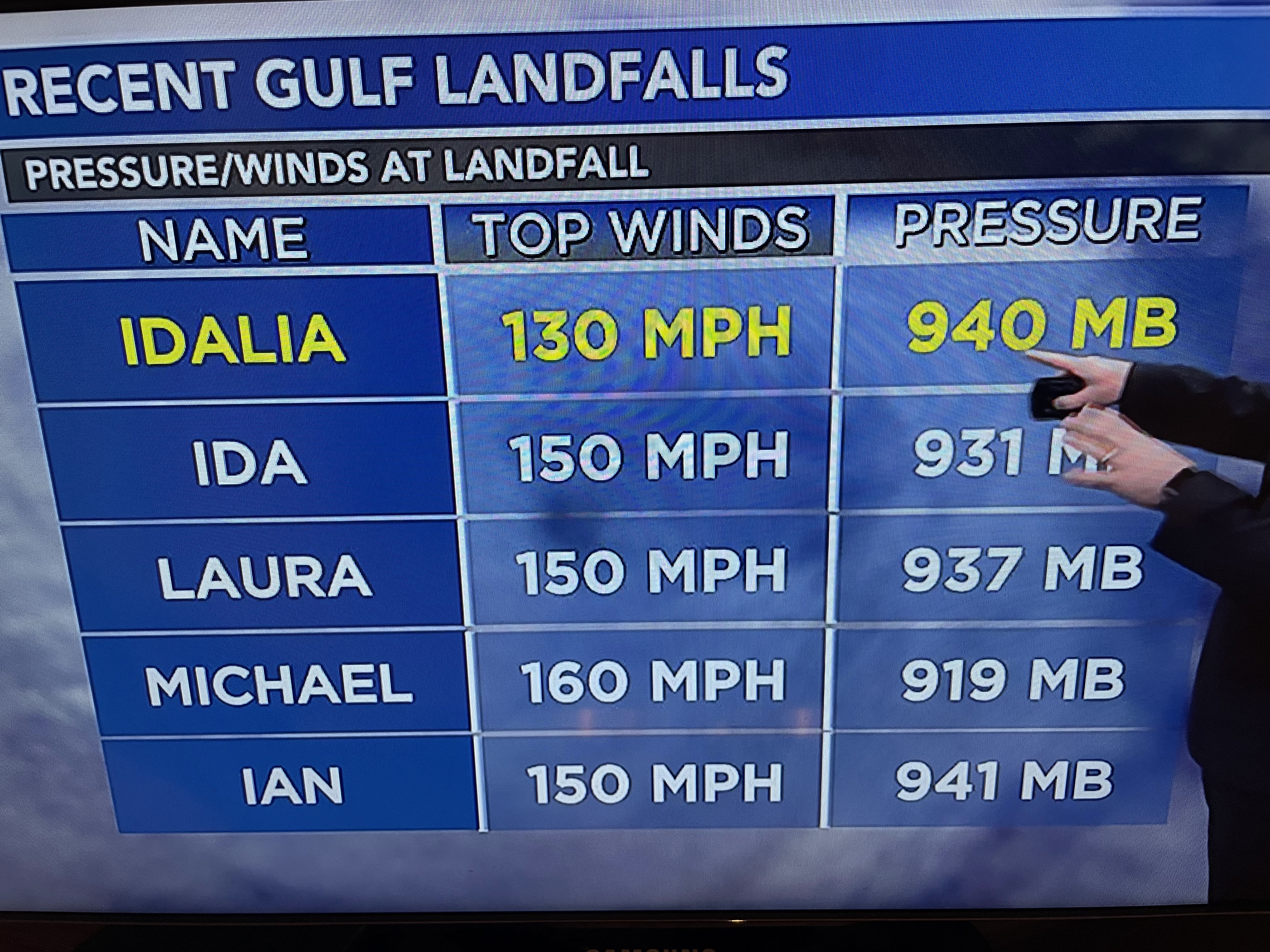
I think we all agree the path of this storm was the best outcome coming ashore where the fewest people & structures were.  Listening to the media use words like "monster storm, devastating or incomprehensible" makes one believe they were overhyping the situation.  Coming back from golf yesterday, Scoot on WWL radio said that's how he felt.  Governor DeSantis told Jim Cantore on The Weather Channel that hurricanes back in the 20s, 30s & 40s were far stronger.  What has changed?  We now have many more people living in harm's way.  This was a bad storm for sure.  But it was no where near as destructive as the past Laura, Delta, & Ida were to Louisiana.   We're not done with the 2023 season.


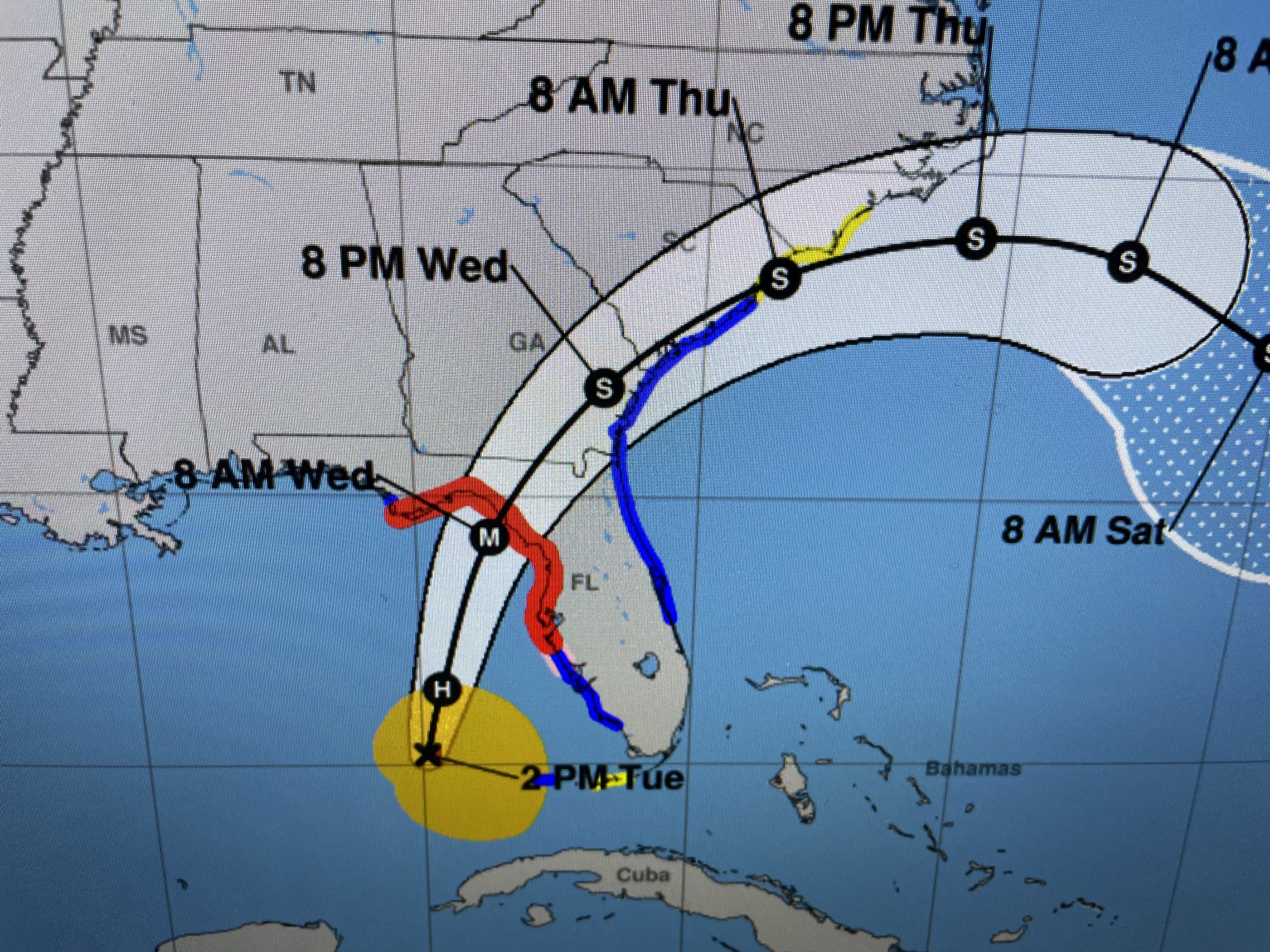
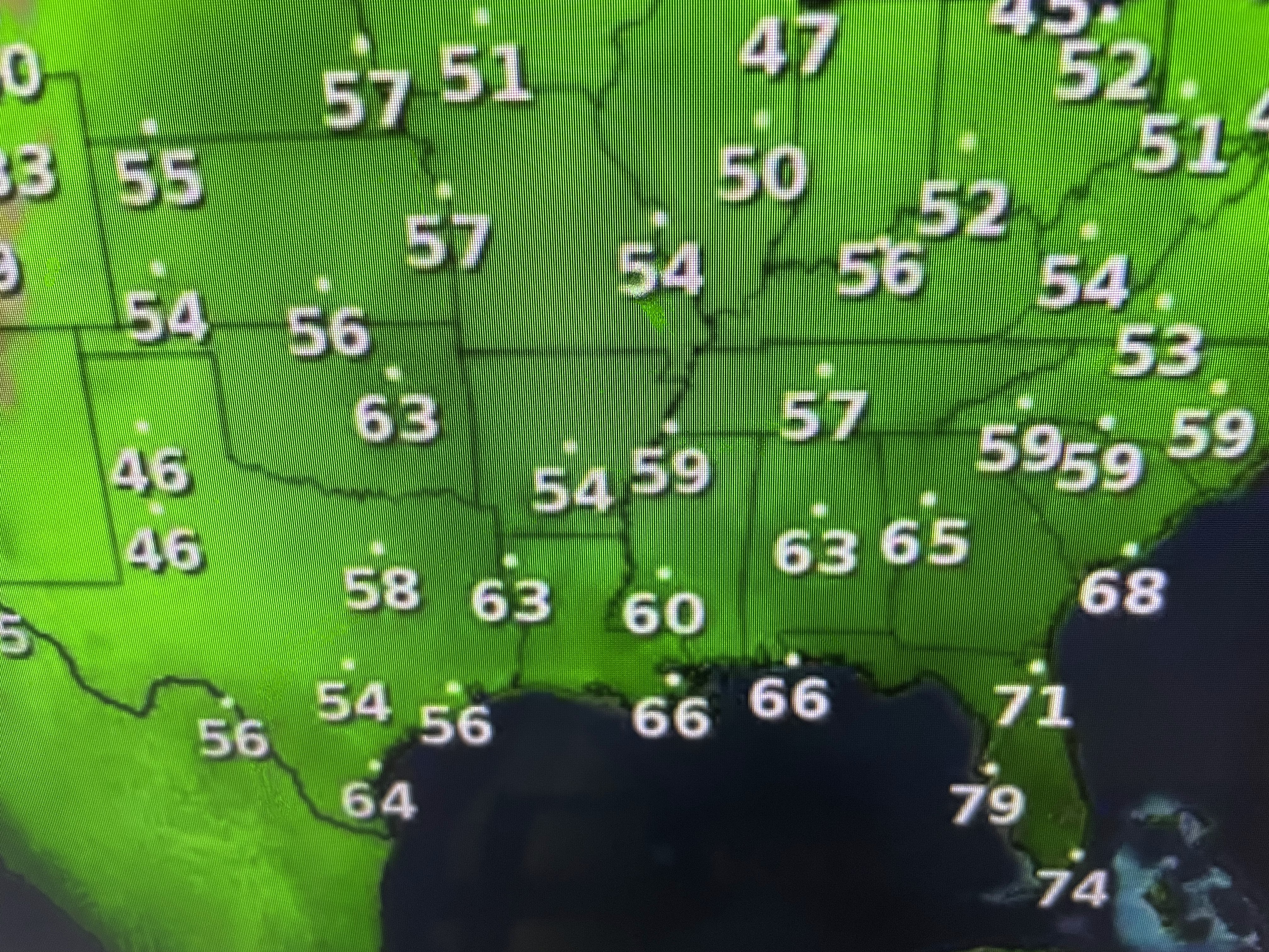
NHC is following 3 named storms with more on the way.  As Joe Bastardi with Weather Bell Analytics pointed out, most of these systems are above 30 degrees north Latitude out over the Atlantic.  Look at how quiet the MDR (Main Development Region) is.


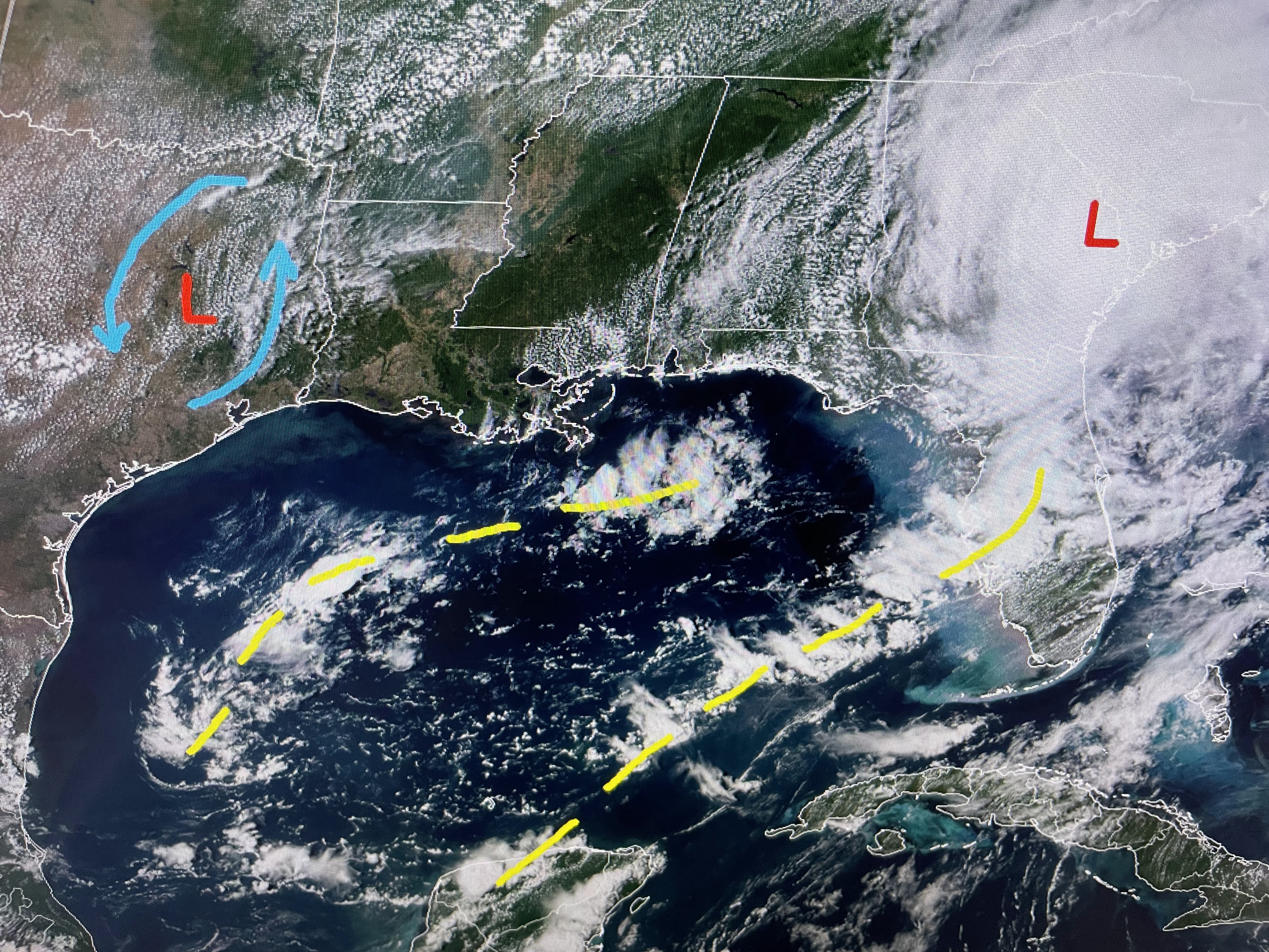
The Caribbean is all quiet, but the Gulf has an interesting feature down off the Yucatan.  There is a weak low along the old frontal boundary with a surge of tropical moisture heading our way for this weekend.


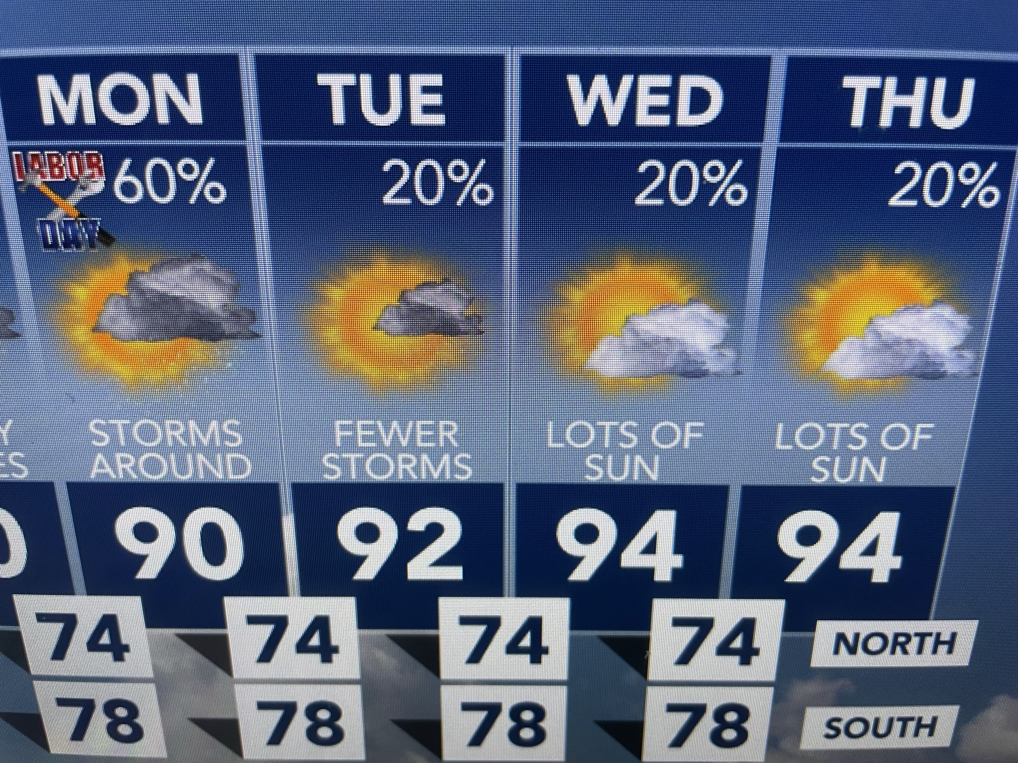
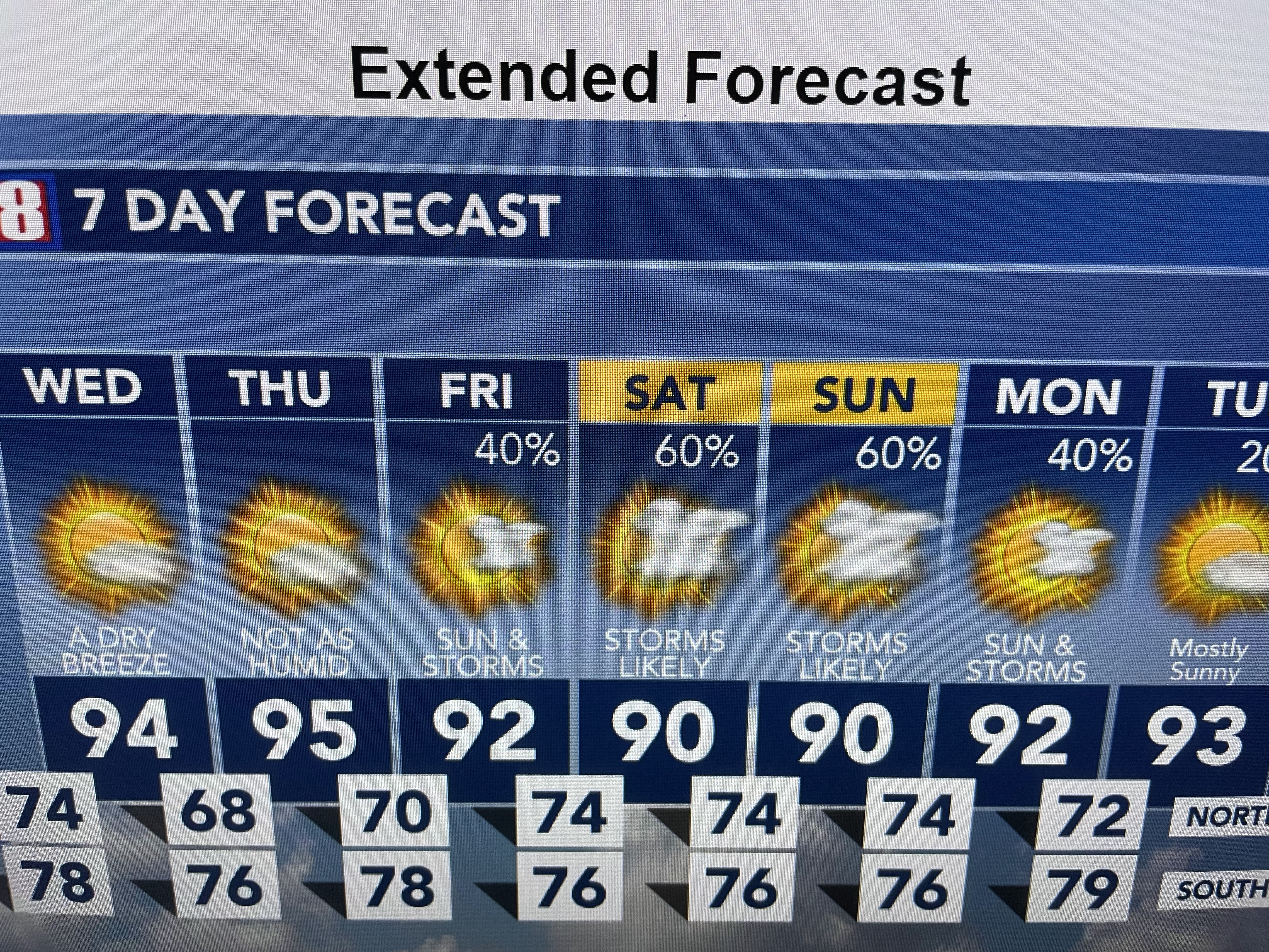
Don't look for it to rain 60% of the time, but these will be tropical downpours that will dump 1-2"+ on some folks.  We need it!


I'm looking for that first real front as we enter September, but based on computer guidance, I don't see it happening until after the 15th.  The 70+ dew points will be back for tomorrow  his weekend making it feel more uncomfortable.


In the short term, satellite & radar confirm T-Storms are not far away.  That should keep us less hot. Keep the umbrellas handy.  Hope you remember where you put them!  Stay tuned!

Wednesday, August 30, 2023

Bravo NHC ON A Terrific Forecast

It's easy to Monday morning quarterback and criticize someone's performance after "the game".  Well,  I want to congratulate all the Hurricane Specialists at NHC for a very accurate forecast track of Hurricane Idalia  5 days out.  They projected landfall in the Big Bend are of Florida and that's where it went.  No wobbles after the loop in the Caribbean and a roaring track to the north just far enough offshore to minimize damage in the major population centers along Florida's west coast.


Landfall was shortly after daybreak with the eye moving right over Perry,FL. a city of around 7,000. If there was one thing good about this storm is it avoided the built up coastal communities.  Idalia brought the highest storm surge ever with Cedar Key topping their old record.


The final surge number reached 6.8 feet with higher totals north of Cedar Key closer to the eyewall.  Remember Katrina had a surge of 28+ feet and Ida 12+ feet.  Kind of tells me the Big Bend area has avoided the major Cat. 4 & 5 Hurricanes.


Idalia has been downgraded to a Tropical Storm on the latest advisory and is quickly moving just west of Savannah.  There is a large heavy rain shield to her north & east and inland flooding will be a problem tonight into tomorrow.  Already some are saying Idalia is a clear sign of climate change.  The bottom graphic says otherwise.  Florida had way more landfalling hurricanes back during the 1800s into the 1940s.  


As the storm pulls away, the northerly flow behind her over us is bring in drier air (lower dew points).  That should last through tomorrow before we start to see the Gulf moisture return.


Rainfall chances really ramp up over the weekend and that should keep us less hot.  We need several days of widespread daily T-Storms to get our state out of drought conditions.  Stay tuned!


Tuesday, August 29, 2023

Idalia Accelerates To North, Now Cat. 2

Many of you know my first job was at WTVT-TV, Ch. 13 in Tampa.  My first hurricane was Agnes during the summer of 1972.  I marveled at my boss (Roy Leep) keeping his cool under the pressure of a Hurricane and I tried to follow his example later in my life.   I mention Hurricane Agnes because her track is very similar to our current Idalia's.  She's just far enough west of the major population centers to not cause any huge impacts.  Somehow the Tampa Bay area keeps missing these major impact storms.


Idalia has increased to a Cat. 2 (winds 100 mph) and is now racing straight northward at 16 mph.  Because the turn to the NNE hasn't happened yet, NHC has shifted the centerline track slightly (20-25 miles) farther to the west.  As I mentioned in my last post, that should mean lesser impacts to the major population centers along Florida's west coast.  The Big Bend communities will receive the main impacts, but they have had plenty of warning to get out.


As a result of the westward shift, the heavy rainfall graphic keeps the 6-10"+ totals well off the coast with only 2-4 inches expected over the land areas south of Cedar Key.


A rather deep upper trough over the eastern states will keep Idalia from turning back towards us.  Her circulation should help usher in drier air for Wednesday & Thursday.  Note the dew point in Houston is 60!


For the second straight day, T-Storms have brought welcome rainfall to many.  This has cooled some folks into the 70s.


I don't see a real strong cold front coming yet, but it appears we're done with the triple digits.  


The rest of the Tropics remains active with Hurricane Franklin still a Cat. 3 and TD # 11 staying way out on the extreme right in the satellite view above.   My guess is NHC will briefly make TD 11 our next named storm (Jose).  Another wasted name.  Stay tuned!