The eastern Pacific has three systems churning with Tropical Storm Greg heading well south of Hawaii. Fernanda is a Cat. 2 (110 mph) hurricane, but it should weaken as it heads to the west. The third system will likely become their next storm later this week. In the past, the "rule of thumb" was IF the EPAC was active, the Atlantic was not. We want the EPAC to stay active.
On our side of the globe, waves are coming off of Africa, but you can still see lots of Saharan dust that should mean little development. NHC is highlighting 2 areas way out there and we don't need to be concerned with them since they are likely to turn to the north. My concerns for the next several weeks will be for closer in development.
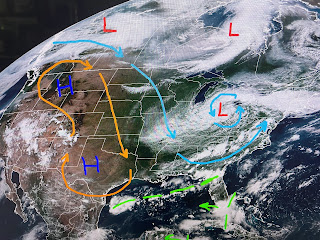
For the first time in many weeks, there are areas/clusters of T-Storms, One is moving into the Yucatan while another is across south Florida. I drew in a yellow dashed line across the Gulf where it appears to me a boundary has set up. Since we have a weak cold front coming down into the northern Gulf, sometimes a swirl can develop along an old frontal boundary (Alicia 1983). It's something to watch for during the next couple of days. It would sure be nice to get a tropical wave here to break our drought early next week. Oops, we've done it again!
MSY has reached 100 for the 6th day in a row. During my 45+ years living here, we have never endured such a long stretch of record heat. Some of that is having the new terminal built around the sensor at MSY. But a little relief is coming.
The upper heat dome has shifted back to our west as a deep east coast trough is driving cooler & drier air our way. Since it's August, don't expect much cooling, but look at the 50 degree dew points (drier air) not that far away. You should notice a difference feel to the air tomorrow morning. Now if only we can get a little rain.
Those storms over the North Shore just bubbled up during the past hour. It would be nice to see them make it down across the Lake.
The cooling relief will be brief as the front washes out and the upper heat dome builds back for the weekend. It appears the center of the dome will stay farther to our north and that might allow some daily storms to bubble up. If not, we're back to flirting with more 100 degree heat. The cool down next week will be from tropical moisture moving in under the upper heat dome. That should give us higher rain chances. Stay tuned!


No comments:
Post a Comment