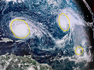
So let's focus on Lee who's forward speed has slowed down to a crawl. He really hasn't gotten stronger, but remains a well organized Cat. 3 (115 mph) storm
There has been a slight shift to the west in the 5 day track which places New England in the cone of error. If you have a trip planned to NYC, Boston or the Northeast, please keep up on Lee for later this week. The other big news to me is the moisture stream coming into the West coast from a dying hurricane.
This could be an indication that the West Coast could be in for back to back rainy seasons, but it could also mean the southern stream could be active over us resulting in a wet November through February bringing an end to our drought conditions. In the short term, there is a frontal boundary that is triggering welcomed rains to our north.
You can see the cooler air (60s & 70s) just waiting to come our way next month.
This might be the last week we have to deal with 90+ temps as the lower sun angle & shorter days should result in less hot temps.
A couple of storms fired off today, but not enough to keep us from reaching the lower 90s. I haven't been fishing since late May due to the extreme summer heat. However, Captain Hylton called and he says he knows where they're biting. I'll be in a boat at first light and will let you know what we catch. Stay tuned!


No comments:
Post a Comment