Since roughly 70% of the lower Mississippi volume comes from the Ohio Basin, we need to see it start raining up there. Some showers are falling on the Upper Mississippi basin, but that contributes only 30% of the volume down here.
So we need fronts to start coming down bringing cooler air along with showers and T-Storms. But that won't happen until we see an upper trough develop over the East Coast. There is a weak upper disturbance across East Texas that might trigger some showers here later tonight. But that should push the stalled weak frontal boundary down into the Gulf for the rest of the weekend into next week resulting in more dry days.
Bottom line, no immediate relief is coming to our dry spell nor no real cold air through much of next week. The cool down will be gradual and mainly due to lower (drier air) dew points.
We actually could use a weak tropical system that moves to our west dumping significant rainfall amounts all the way up to Memphis and Louisville. No model shows that happening.
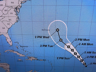
All the tropical activity remains far out in the Atlantic. TD # 15 (soon to be Nigel) is expected to stay well out to sea. Hurricane Lee is hanging on and will give New England a glancing blow. He still packs quite a punch as the 25+ foot wave heights confirm.
Everyone has been warned that Lee is coming so I expect the impacts will be no worse than a typical Winter Nor'easter.
We could see the showers in Texas move across us after dark, much like last night. I'm just tired of the 90+ heat and will enjoy the 70s & 80s of October. Enjoy your weekend & stay tuned!


No comments:
Post a Comment