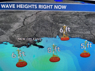
The warm air sector stayed east of the surface low and never made it inland. The strongest, heaviest storms are offshore heading for the Florida beaches later tonight. Much like Nor'easters in the Winter up north, this weak disturbance south of our coast created some impacts common to a tropical system.
Brisk ENE winds gusted to above 40 mph piling water into Lake Pontchartrain that lapped over the seawall on the South Shore. Expect improving conditions later tonight, especially after midnight. What is really encouraging is a Pacific disturbance that will soak the upper Mississippi Valley on Friday.
1-2" rain totals will be common with 3-5" across parts of South Dakota. It will take 10-14 days for that water to reach us and raise river levels. Hopefully more will follow?!!!
Once today's disturbance pulls to our east, look for nice warmer weather to return. Note how warm it is back in the sunshine.
Our next front won't arrive until Friday night and ahead of it will be a warm up back into the mid 80s. Next weekend will be a repeat of this last one as highs will be in the 70s with nights in the 40s north & 50s south. Oh how I do like Fall! I've put in a call to the "Fat Lady" as models have no development in the Gulf during the next 7-10 days. Stay tuned!


No comments:
Post a Comment