The shorter days and lower sun angle will begin to show up with colder temps., but for now it's just cooler air. There is an upper low over the northern Plains that will bring us another weak cold front.
Since the air behind that front is only in the 50s & 60s, by the time it reaches us, all it'll do is bring us back some drier air.
As I mentioned yesterday, our chances for seeing any rain along the front are slime & none and our drought pattern shows no real signs of ending.
In fact, after a delightful spell of cooler weather, October will close on a warm note. Finally, the Tropics are active, but not around us. I've circled areas of disturbed weather. Two are named storms.
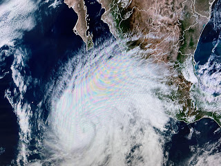
Tropical Storm Tammy formed out in the Atlantic and will brush the Islands before turning to the north on a path out to sea, In the Pacific, Norma will become a major hurricane.
She will approach Cabo San Lucas before weakening and heading inland. It would be nice if some of her moisture could come northward into the U.S. Stay tuned! I'll be out fishing with Capt. Hylton tomorrow so my next post will be on Friday.


No comments:
Post a Comment