There is currently a stalled surface front over the western & northern Gulf. A strong upper disturbance in Mexico is lifting towards the northeast triggering a wide area of moderate to heavy rains. That will move across Louisiana & Mississippi Monday & Tuesday with totals of 2-4" of much needed rainfall.
There is no really cold air except up in Canada, so once this low passes and the sun returns later this week, temperatures will bounce back to 70+.
Hannah Gard showed us this morning that the Gulf low will be a slow mover with showers lingering into Wednesday.
So look for the next 2-3 days to be breezy, cool with periods of moderate to heavy rainfall. Those strong easterly winds will result in some coastal flooding during the high tide cycle. finally...
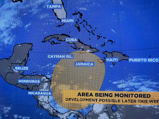
NHC isn't giving up on one more named storm somewhere down over the central Caribbean. Nothing is there yet and that idea is based on computer model forecasts. Regardless, it will not be a problem for the U.S. as strong WSW upper winds will carry it off to the NE. Try not to let the Saints get you down as the weather will be enough to give us that sad feeling. Stay tuned!


No comments:
Post a Comment