I've drawn the upper split over the satellite views and you can see the colder/higher cloud tops (orange & red colors) over the eastern Gulf corresponding to the surface radar returns. Note how a new area with lightning is forming along he upper Texas coast. That's our next wave of rain coming later tonight with yet another arriving for later on Saturday.
until that upper trough shifts to the East coast, we're stuck with the SW upper flow that will slow the weak frontal boundary over Texas from blowing across the northern Gulf.
During the day on Sunday, some slightly cooler & drier air will overspread our state making for several nice days heading into next week.
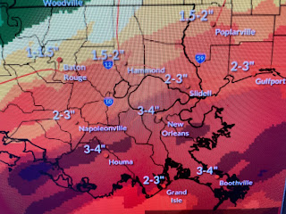
So my concern tonight focuses on where the training of storms sets up. The NWS rain graphic has the heaviest rainfall totals south of Lake Pontchartrain, while Nicondra showed a heavy rain graphic that put the North Shore with the heaviest. Perhaps it'll be BOTH sides of Lake P.?!!!
Bottom line, all of us need to pay attention tonight & Saturday IF you plan on traveling around. This includes the Mississippi Gulf coast. Let's not be caught with our guard down. Have your FOX 8 weather app updated and keep the phone nearby in case warnings are necessary. I'll update again tomorrow morning. Stay tuned!


No comments:
Post a Comment