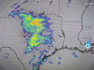
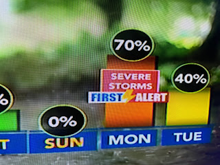
Since the Mardi Season kicks off this Saturday, it seem appropriate for the "Krewe of Storms" to arrive for us. It-s a very progressive (fast) upper air pattern that starts over the Pacific and heads across the southern U.S.
Hannah Gard mapped out on her 4 pm program the arrival times for our wet weather. She called them "Our Parade of Storms".
So the drought busting wet pattern of December looks to continue for the first half of January. Let's deal with the 1st disturbance coming for tomorrow. The upper low over west Texas appears to be weakening with most of the rain falling in the split in the Jet streams (lime green circle)
There has been some lightning with this system earlier, but that has diminished.
The surface frontal boundary remains way down in the Gulf with only a slight rise in the dew points. That should mean rainfall totals should be limited along with the fast eastward movement.
7 day rainfall totals predicted by models give us 4-6". However, the bottom view is for the next 2 days indicating amounts of 1-2". I'll be surprised if we see that much.
So the bottom line is we'll have 3 opportunities for significant rain tomorrow, again on Friday and again on Monday. SPC is already indicating next week's system could be the strongest with the potential for severe storms. We have many days to watch it.
Looking at the seven day forecast, I don't see any freeze threat for the South Shore with only a light freeze north on Thursday morning. Stay tuned!


No comments:
Post a Comment