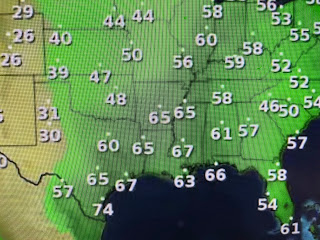
It had been almost 2 weeks since our last soaking rainfall, so the quick drenching we received between 10-1 PM was welcomed by lawns & gardens that had begun to dry out. However, the weather pattern that has been keeping us mostly dry, is setting back up for later this week that will bring a repeat threat for severe storms over areas that were battered by tornadoes over this past weekend. Let me explain what is happening and show some graphics confirming the pattern. We begin with the upper air flow. The trough over the West & a ridge over the East continues as yet another upper low dives along the Washington Coast.


Satellite views show how the Plains have cleared out behind the strong low near Duluth. The classic comma shape indicates a powerful system. The next two graphics are from the SPC for Tuesday & Wednesday keeping a level 2 risk over the Plains. Note, the bottom graphic is the 7 day rain totals that lines up with where the severe threat is. Our weather is strictly upper air driven as the surface front has stalled well to our north.
In fact, dew points show no drier air is coming. What we should see is warmer temps. returning Tuesday as the sun pops back out. Radar has most of the rain pulling away with all the lightning far offshore.
Heaviest rainfall was centered west of BTR while the brisk winds for the past several days are diminishing.
The 7 day outlook keeps us in the 80s as no front is coming. NWS indicated in their discussion that Friday's rain chances might stay well to our north, which would make for another dry weekend for Jazz Fest. Rain chances won't be zero since we'll remain in a humid airmass. Stay tuned!


No comments:
Post a Comment