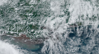
Many of you who have followed this blog over the years know I have been critical of NHC naming "nothing burger" storms. Some storms have lasted less than 12 hours and I often said it was a "wasted name". Not so with Tropical Storm Alberto who was named at 10 AM this morning. In fact, I thought/felt NHC could have named it last night since buoys across the northern Gulf were reporting winds of 40-50 knots. Yesterday I mentioned an apparent jog to the north was probably just a re-location of the center since it was so ill defined. It's still just a very broad circulation with several swirls in the mid levels.
As you can see in the bottom color view, Alberto does not have the structure of a well defined Tropical Storm. The newest NHC 4 PM advisory places the surface center nearer the SW white circle.
Alberto is heading towards the Mexican coast and will be on shore & inland before daybreak. The strongest winds are well away from the cone of error/uncertainty and that is why NHC is placing the Tropical Storm force wind field and warnings with their official track. Impacts often well outside that cone giving some folks a feeling they will see no impact. Alberto is a good example of impacts extending far away from the center of circulation. So what else is happening in the Tropics? Let's begin off of Africa where there is a swirl of clouds.
Fortunately, there is a huge plume of Saharan dust spreading westward and that will limit any development. Closer to home, NHC is watching an area east of Florida.
Whatever forms (NHC gives it 20%) will be steered westward into Florida & Georgia. Another area for development might be back over the Bay of Campeche for next week. We should have no tropical threats for the next 10-14 days.
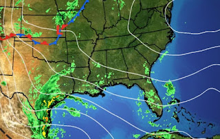
It's certainly a tropical feel over all of the eastern states with many dew points 70+. Worse yet, it's hotter up over the Northeast where they aren't used to our heat & humidity.
We have some clouds and showers around that have provided some cooling relief.
So go ahead and call your buddies up north to tell them how nice we feel today. Begin with "How's your weather"! He-He!


.jpg)
.jpg)


No comments:
Post a Comment