
After a terrific 4 days in Ohio enjoying dew points in the 40s, one must return to home & reality of 70+ dew points. Before I left, NHC was watching an area for tropical development in the southern Gulf. They're still watching only with many more eyes. Recon Aircraft have been trying to find a center of circulation, but soon to be Alberto has several centers rotating around a broad circulation. What appears to be a track to the north is more a relocation of the apparent center.


I've drawn in the broad circulation (Lime green arrows)with a slug of tropical moisture moving over us. Note on the color view the oranges & reds are not around the center of PTC 1. The Recon found surface pressures are not falling so NHC is not naming this system just yet. IF it does develop over night and on Wednesday, we should see fewer showers and less winds here. For now, NHC is keeping soon to be Alberto on a track into Mexico with some heavy rain impacts for south Texas.


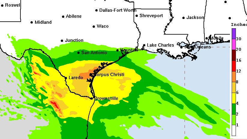
In an effort to provide more information, NHC now includes the tropical storm force (orange area) wind field on their official forecast track. In addition, they are placing current warnings (dark blue) along the coast lines. The heaviest rain totals are aimed at south Texas.
So this first to be named system will not be our problem. However, the Tropics are just waking up. There are several disturbances east of Florida, plus a new tropical wave coming into the Caribbean.


.jpg)


The next several days will be basic (what used to be) summertime with storms along the coast before dawn redeveloping inland during the day. Coverage should be 30-40% with many dry hours in between.


All of the Southeast is "enjoying" summer like temps as we approach the Summer Solstice at 3:50 PM Thursday. Note the 70+ dew points (tropical feel) dew points extend up to Chicago, Detroit, Cleveland & Buffalo. Our local short term concerns are winds & high tides with a Coastal Flood Advisory up.


It will take some time for the winds & seas to calm down so stay off the open waters of the Gulf. Radar shows the rain area has pushed away from us and we should be mostly dry for tonight. Good to be back Gang. Stay tuned!


No comments:
Post a Comment