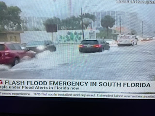
With almost every major weather event, there is a lesson learned if you look for it. Take today for example. NHC had indicated yesterday that a weak low could for along a moisture surge coming out of the Caribbean. They have moved that slight development area farther to the east of Florida, but look what's happened to south Florida "just from a tropical disturbance." Officials have declared a flood emergency. Take a look.
Just because a tropical disturbance isn't a named storm or hurricane, you can still get major impacts from super heavy rainfall.
I kind of snickered when I saw yesterday's 12-18" prediction for parts of south Florida. Well, stop snickering weather breath! The models were correct.
Haven't these kind of flooded streets here happened just from 2-4" of rain? Think of what might happen IF 15-20" fell in one day? That's why we must pay attention to ALL tropical disturbances, not just the ones with names.
That tropical boundary has shifted southward during the day taking the heaviest rains from central Florida to south Florida.
As that boundary keeps going to the south Miami is finally getting a break. So what about that other area in the southern Gulf?
There is a weak mid level swirl approaching the Mexican coast, but that is NOT what NHC is watching. Computer models are hinting at some development later this weekend into early next week. The model trend has been to keep the really heavy rains moving westward into Mexico and NOT northward towards us?
So unless we get another tropical disturbance to spring up, our weather will continue very hot and mostly dry with only daytime heating storms developing along the sea/lake breeze fronts.
So the difference in the seven day is to downplay the surge in rain chances for us this coming weekend.
As Bruce indicated on his 5 pm broadcast, those 60% rain chances might be too high for next week. I hope not because we really need some soakers with the daily 90+ heat. I will be on the road for several days and might not be able to post since I won't know about internet access. Stay tuned to FOX 8 for the latest tropical information & updates. Stay tuned!


.jpg)


No comments:
Post a Comment