
There has been a lot of chatter on social media regarding something forming in the Gulf. There is NOTHING forming in the Gulf, However, NHC has started issuing in their Tropical Weather Outlook an area that has a slight (20%) chance to develop later this week...and it's NOT in the Gulf. Let's go to the Graphics. They are calling the "X" Invest 90-L, but surface data doesn't show a circulation.


I've dashed in a boundary extending from the Yucatan across Florida out into the Atlantic. If you look closely, there appears to be a weak mid level spin SW of Tampa. The color satellite view indicates lots of T-Storms along the boundary, but there is no organization.


Central & south Florida are getting soaked and that was predicted.

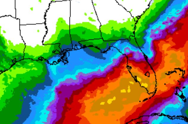

The middle graphic is the WPC's 5 day rain totals that centers the 8-12"+ totals over south Florida. However, look at the bottom graphic. That suddenly brings some heavy rains into south LA/MS for Sunday and early next week. That will not come from the current heavy rains falling over Florida. Westerly upper winds over the northern Gulf will keep the rain over Florida for the rest of this week.


You can really see the old frontal boundary across us in the dew points. North of Lake Pontchartrain they are in the 50s & 60s. It's still hot, but much less humid.


The next 4 days should see little relief from the heat as we will stay mostly dry. The change comes on Sunday as computer models bring a tropical wave across the Gulf into Texas and south Louisiana. Neither the Euro or GFS develops a closed circulation with this wave, but it's something to pay attention to for early next week..


There is a small upper low over Texas, and if it shifts farther to the ESE, could bring us a few showers tomorrow & Thursday. Let's hope it does, otherwise use the common sense precautions in dealing with our summer heat. Stay tuned!

No comments:
Post a Comment