
I'm writing this well before the 4 PM NHC advisory comes out. All of you have noticed how the centerline track has shifted from a Mexican landfall to a landfall in south or central Texas. That is a disturbing trend that should make LA/MS coastal residents go into PAY ATTENTION time. Here's what I'm seeing on satellite loops that indicate 1) Beryl has made a jog to the north this afternoon meaning 2) her center will spend less time over land and re-emerge over the southern Gulf tonight. I begin with Beryl's past track.


The centerline passed just south of Cozumel last night and was supposed to stay over the Yucatan ALL DAY today. But here's what I'm seeing.


It appears the center of Beryl is already nearing the coast and will be back over water shortly. That should allow her to once again gain strength. Note how this is a weighted east side (white arrows) moisture storm, meaning, where that centerline track goes, will be super important. Of concern is the most recent model runs. The top is the European model valid for Monday morning that brings the center/eye near Houston! Yikes, that's quite a shift back towards us!


The bottom graphic is the GFS for the same time on Monday. It places the center closer to Corpus Christi, not as alarming for us.


The bottom two graphics I grabbed off The Weather Channel showing many storms that cross the northern Yucatan head to south Texas. What concerns me is the name HARVEY back in 2017. Remember, that storm stalled for days giving metro Houston 40-60" of rain. Beryl was a fast moving Hurricane for many days. It appears her steering has weakened resulting in a slower moving storm. Let's look at the current steering. Gone is the upper heat dome that has shifted back over the western states.


Without the upper blocking high and several upper disturbances (Wisconsin, Montana) diving into an eastern trough, the avenue to move more northward is there. My gut says between Houston & Lake Charles and that would increase impacts for us. So let's look at the newest thinking from NHC on their 4 PM advisory. It's now down to a Tropical Storm.


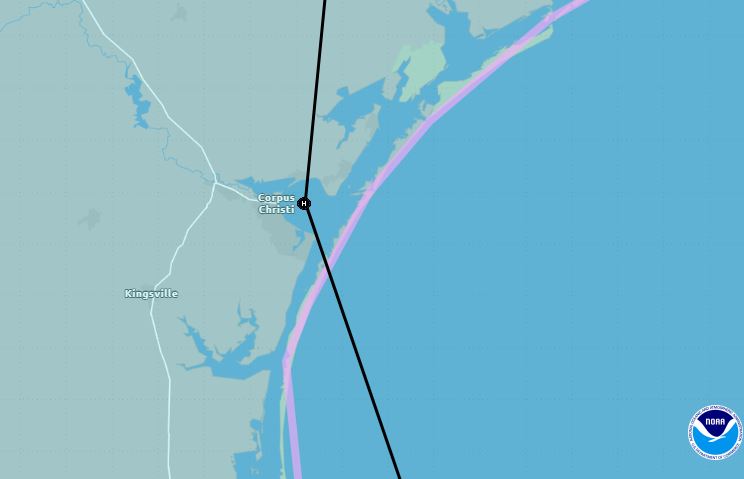
As you can see, NHC has chosen the GFS over the Euro pointing out that the Euro is on the eastern side of the cone. Corpus Christi is now the centerline track for landfall, however, any further shift to the right keeps Beryl's center/eye over water much longer. That will make a world of difference as the cone of error now extends into Louisiana. What if the Euro proves reality? Then impacts for us would be much greater, especially rainfall. Here's their current thinking. The oranges & reds are 5-10"+. You can see what a shift to the right would bring us.


The bottom graphic is the arrival time when beryl's center reaches the coast. Personally, I think they're way too fast. Bottom line, if you have heard Beryl will have no major impacts for LA/MS, that still could happen. What I'm asking you to do is follow that centerline to see if it's going where NHC says (Corpus Christi) it will. Any further shift to the right will bring greater impacts to us. Just remember, Beryl is NOT the beast that struck the Windward Islands as a Cat. 5 right now. Could she regain strength back to a Cat. 2 or even a three? Absolutely, but she will not be another Katrina or Ida for us. Let's just not let our guard down until we know for sure that Beryl is Texas' storm. Stay tuned!

No comments:
Post a Comment