
When I started on Ch. 8 back in April 1978, I recall my 1st Hurricane special was focused on 2 storms (Betsy '65, Camille '69) that everyone back then remembered. They both had major impacts on SE LA & coastal Mississippi. The 70s & 80s didn't see much as tropical activity was limited by a cooling Atlantic. (Juan '85). The late Dr. Bill Gray correctly predicted that would change during a warming cycle in the Atlantic beginning by the mid 90s. Hurricane Andrew ('92) sounded the first alarm that storms would be on the increase. I don't have to remind long time residents that August 29th would become a special, dreaded day forever due to two storms (Katrina '05, Ida '21) that disrupted our lives & killed many of our loved ones. We have seen many others, but those 2 Hurricanes stand out. My focus will be on the Tropics for the next 6 weeks as this is the Heart/Prime Time of Hurricane activity. NHC is focused on the Atlantic MDR.


The Euro & the Canadian models are developing a named storm by early next week while the GFS does not. The first wave (yellow dashes) goes into the Caribbean while the second (Low off Africa) is headed farther north of the Islands. Certainly, we will watch these systems, but they are so far away. Let's focus on the Gulf that still is very unsettled.


I've found several mid level swirls, but radar views find only a broad rotation. In addition, I checked surface pressures and they ate NOT falling. What concerns me is this "area of disturbed weather" will linger for another few days. That will cause total rainfall amounts to exceed 10" to our west.


WPC has the bullseye of heaviest rains from Galveston to near Morgan City. However, can you see the spokes/ bands of storms? If you get caught under one of these bands (training), Street flooding is very likely. NWS has already issued flood warnings for some locations. So is there anything that might draw this moisture away from us? Not in the short term.


There is an upper trough moving over the northern Plains bringing a cold front into the Dakotas. but that trough will not be strong enough to bring the front down to us. Look at how many are suffering with the high dew points and hot temps. At least today's storms brought us some relief.

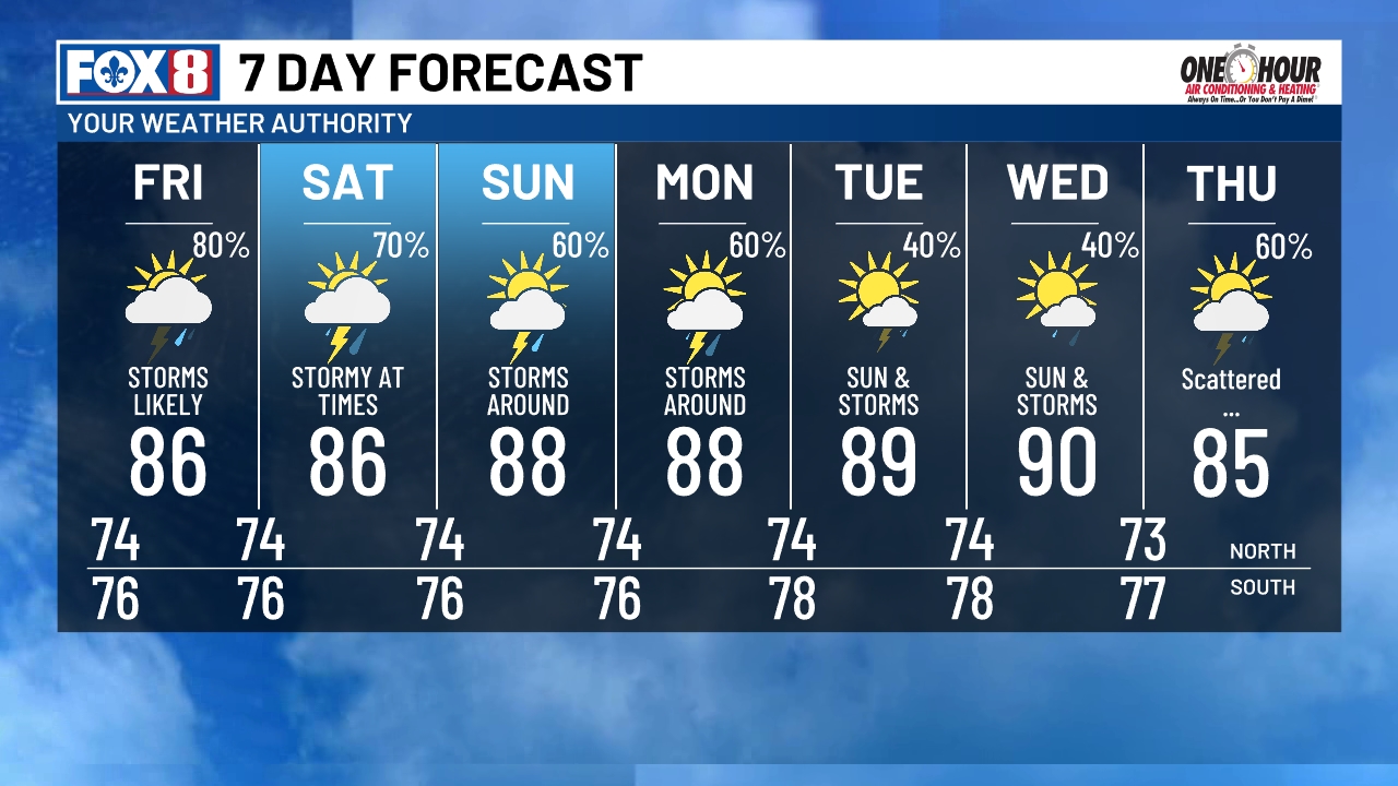
In fact, the clouds & higher rain chances should keep us below 90 into next week. What I will be watching for over the western Gulf during the next 2-3 days is any concentration of T-Storms offshore. That is not happening yet.

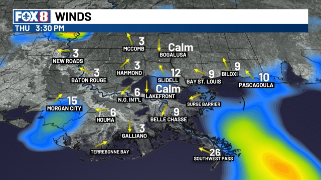

There has been an increase in the SE wind flow with SW pass reporting 20-30 mph. Note how the wave heights have increase from 1-2 feet yesterday to 4 feet today. IF a depression does form, we will be on the "wet side" of it. Channel 8 rightfully issued a First Alert yesterday for Thursday through Saturday. Let's just pay attention to the weather in case we start to see impacts that would restrict travel due to street flooding. NWS has placed us under a Flood Watch for tonight & Friday. Stay tuned!
No comments:
Post a Comment