
I've often mentioned that the "Tropical Cake Mix" is more than just water temperatures and wind shear. We have seen this summer the Saharan Air Layer (SAL) or African dust is also a factor. Another key player is the MJO (Madden-Julian Oscillation) which is a pulse of clouds & rainfall that travels around the Tropics all year. There is a suppressive phase that has sinking air motion, and an enhanced phase that supports rising motion. Typically the active/enhanced phase is called 2-3 for us and that is where it's going this week. So do we see anything in the Tropics that might develop due to the favorable phase? I see three areas to watch. (yellow circles)

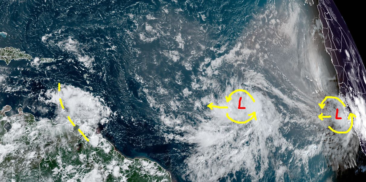

The color infrared shows those 4 clusters of storms, yet NHC is only focusing on the middle one (Invest 98-L). Why just the middle one? Because models only develop that one and leave the other two alone. With the MJO being favorable, I'm watching all three.


Invest 98-L has hints of satellite rotation, but it's still way out there. A word of caution, even though early model runs all turn soon to be Ernesto away from the East Coast, we've learned from experience that that turn could be later bringing a threat to Florida and/or the East Coast. I don't see it ever getting into the Gulf as we have a persistent upper East coast trough that has forced the Bermuda high/Atlantic ridge farther eastward allowing an avenue for Ernesto to turn to the North. In addition, our upper Heat Dome is hanging around.


That has brought a taste of Fall to the northern states. Maybe in another 4 weeks, we could see some weak fronts dipping down our way?


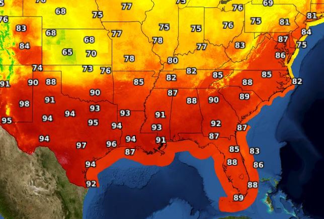

For us, some lower dew points have made our heat more tolerable. That will slowly change for next week as some spotty PM storms could break through the upper cap.
.jpg)
My house has gone 13 days without any rain, and with our high temperatures, the lawns & gardens are starting to brown.


There are some nearby storms just east of the Florida beaches and along our coasts. We need some of that moisture to work northward this coming week. Finally,

I've been showing you some of my wife's artwork. I have 4 bird feeders in my yard and love to watch the various birds come eat. Brenda added some color to a bird she calls Cleo. Her website is coming next month where you can view all of her artwork. I'll post when it's ready. If you want to reach out to her before then, her e-mail is brendabreck@gmail.com. Stay tuned!
No comments:
Post a Comment