TWC mentioned the average date for our 5th named storm is August 22nd, and it appears we will be slightly again of schedule by about 10 days. That's not bad for a season that was supposed to be "hyper-active". We still have plenty of time for a big ramp up over the next 6-8 weeks, but models are not showing anything but Ernesto for the next 7-10 days. With nothing to talk about locally except more heat, let's start as always with the Tropics. Yesterday I mentioned the MJO was going into the favorable/enhanced phase for the next 2-3 weeks and that should mean we'll be tracking several storms. I showed you 3 areas yesterday. We still have three today. the one over the Caribbean yesterday is gone.
A new area has flared up over the southern Gulf, but it's moving westward inland over Mexico. Back out over the Atlantic MDR, the first low is more in the mid levels as NHC is indicating there is no surface rotation yet. But it's coming so they have started to issued advisories for Potential Tropical Cyclone (PTC) # 5 mainly to alert the Leeward Islands and Puerto Rico.
On the visible loop, you can clearly see a rotation, but the color view doesn't have any T-Storms except on the northern side. Spaghetti models have been saying soon to be Ernesto will bring a tropical threat to PR & the Leeward Islands before turning northward away from the U.S.
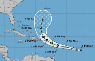
NHC's official track pretty much follows model guidance. Note, Puerto Rico would be on the weaker side of Ernesto IF the centerline track proves reality. I suggest those with interests/family/friends in that part of the world to follow the centerline trend for the next couple of days. At this time, NHC doesn't strengthen PTC 5 into a hurricane until after it pushes to the north of Puerto Rico. Bermuda needs to pay attention since this could become a major Hurricane later next week. So why will it make the turn and not get into the Gulf? It's not the Heat Dome that will turn it.
The Heat Dome is still there, but far weaker than last August. What will turn Ernesto to the north will be the persistent upper tough over the East Coast that has forced the surface Bermuda High/Atlantic Ridge to back off to the east. That has opened up an avenue for Ernesto (and maybe future storms) to make the recurve/turn. Note, I have 2 more upper lows that look like they will travel the same track as the low over NY. Bottom line for us, I see nothing entering the Gulf for the next 10-14 days. But until soon to be Ernesto makes the turn, we all should pay attention.
Locally, there still isn't anything to talk about except the heat. Because of lower dew points (drier air) that wrapped around Hurricane Debby, it's hot, but not awful. What we need to see is the return of a normal daily T-Storm regime.
So far, the storms to our north are fizzling while the ones along the coast are not moving.
At least we have some clouds with the sea breeze front that rings Lake P. to the Florida beaches. Without any rain, we're back into the mid to upper 90s.
All we can hope for in August is for the daily storms to return to bring us some heat relief. Usual common sense heat precautions will be needed. I close with another bird painting from my wife.
She calls it Chloe. Being from Indiana, it looks like a robin to me. They show up big time each Spring. Here down south, not so much. Brenda's website will be coming early in September. If you want to see more of her work, go to Instagram@BRECKBRENDA or contact her e-mail at brendabreck@gmail.com. We will be visiting with out of town friends the next three days so I will not post again until Thursday PM. IF Ernesto doesn't make the turn, I will post as necessary. Stay tuned!


.jpg)
.jpg)

No comments:
Post a Comment