One reason I lasted so long as Chief meteorologist for Ch. 8 is I wasn't just "spooned fed" data from the National Hurricane Center. I quickly learned, after watching Nash Roberts, my competitor on Ch. 4, all the NOLA viewers wanted to know was, "Yea, but what does Nash think?" So if I was to be successful, I HAD to offer MY opinion and not just repeat the guidance information from NHC. It doesn't mean I always disagree with the Hurricane Specialists, I offer added information based on education & experience. I will do that with soon to be Debby, but we begin with the official data from NHC.
You know I'm a centerline track geek since it often indicates a shift/change in where the future tracks are heading. Hurricane Beryl was a classic example. So do you see any difference in the 4 PM track vs the 10 AM? Only if you compare the centerline. The top was the centerline forecast issued at 10 AM.
The bottom is the 4 PM advisory. Can you see NHC shifted the track slightly to the west about 20 miles? Is that a trend? Or is it because we have yet to identified a center? Here's what I'm seeing on satellite views. It sure look like Invest 97-L is trying to organize with some curved bands on the north side.
I place the center of the Low south of the NHC position which would keep it over water tonight. However, the color infrared is not indicating any organization. One blog comment asked, "what if it stays a wave, would it go farther to the west?" Perhaps, but that does not mean much for us because the upper pattern is in our favor. Let me explain.
Here's the current upper flow with the Heat Dome centered over Texas and an upper trough diving down over the Ohio River Valley. That trough should draw soon to be Debby to the north as all computer models predict.
But models have been wrong before. IF 87-l stays weak and does not turn to the north, where would it/she go? Again we're dependent on the models. Here's next week's upper air forecast beginning with next Monday.
The Heat Dome is still there and stays all week. So IF 97-L stays weak and IF the current east coast trough doesn't pick it up, it should go westward well south of the Louisiana coast. So as I mentioned on previous post, unless something major were to change, this is Florida's storm and then watch out Georgia & the Carolinas for next week!
The current rain forecast from NHC brings 8-12" along Florida's west coast, but look at those totals off the Carolinas! We will be dealing with Debby for many days. Worse yet, I'm sure some of you have noticed the GFS for the following weekend? It has Ernesto south of NOLA on Sunday August 11th.
By Tuesday it takes the storm towards Houston. Is that believable? Nah. The GFS model is notorious for developing storms in the 10-14 day time frame, but nothing ever happens. I mention it because it's August any tropical activity should increase this month. Let's hope not.
Whoa! Is that a cold front on the surface map? Not really as there is little cooler or drier air behind it. It's more an upper feature that might increase our rain chances for Saturday afternoon & evening.
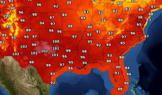
The FOX 8 seven day increases rain chances tomorrow, and even though it doesn't show it, that might keep highs 95 or lower? Bottom line Gang...it's August and it will stay hot into September.
Finally, I know most of you aren't into weather like me. but look at this tight satellite view shortly after dawn. You can see the tall cloud tops creating shadows on their western side as the sun comes up in the east. Stunning! OK, maybe just neat! Stay tuned!


.jpg)
.jpg)

No comments:
Post a Comment