We all know TWC sends Jim Cantore to a location they believe will receive the greatest impacts during a hurricane. So where's Jim going? My guess is between Abbeville to Morgan City based on the latest track info from NHC. I know you all get on-line to look at the NHC discussion & graphics, so I won't repeat what you already know. I will point out things I think you SHOULD know. Let's begin with their 10 AM official track.
You should know the Hurricane Watch to Grand Isle falls OUTSIDE the cone of error as does the Tropical Storm Watch & Storm Surge Watch. If you have been following me for years, I focus on the centerline track to see if there is a model trend that's shifting one way or the other. With a Hurricane, if you can avoid the EYEWALL, you avoid the worse damage & threats to life. So what has that centerline track been doing? We begin with the initial forecast from yesterday at 4 PM.
That first track was west of Lake Charles. The middle pic is from 10 PM last night shifting the track to the east of Lake Charles. The latest 10 AM (bottom view) track is now east of Lafayette. You get the drift farther to the east with each advisory? What does that mean if that shift trend continues? Greater dangers to SE LA/MS. In fact, look at one model that is even farther to the east.
This brings the eye close to Morgan City on Wednesday with 100 mph gusts. But zoom in and you'll see 70-80 mph gusts for most of NOLA. That will cause numerous power outages. Anyone along the coast outside the levee system must move inland including Grand Isle. Here's the forecasting problem right now.
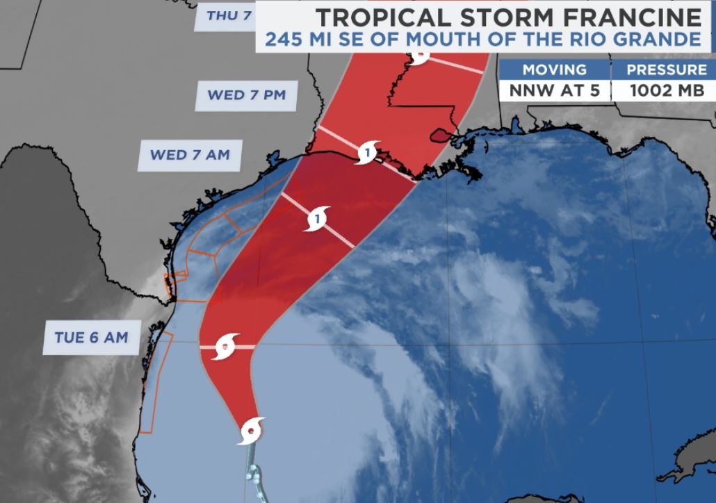
Tropical Storm Francine is looking more and more like a developing Hurricane. The color IR pic has that concentrated cluster that was spread out yesterday. Current motion is a NNW drift with NHC expecting a turn to the NE (back towards Louisiana) tomorrow. The steering is around an upper high near Cuba that is pushing Francine to the NNW.
As you can see, along the Texas and Louisiana coasts the upper flow is from the SW. That is why models are turning this storm back to us. But what if it keeps going closer to Texas before making the turn? RIGHT NOW, all indications are this is a southern Louisiana/Mississippi storm. So the next question is, how storm will it be?
Several models bring it up to Cat. 2 intensity and we all know our levee protection/risk reduction system will handle that. What won't handle the 75-100 wind gusts is our power grid. We need to plan for widespread power outages Wednesday into Friday.
As with any tropical system, storm surge and flooding rainfall is expected. The highest wave heights are down over the southern Gulf, but that will change when Francine turns northward. The approach motion coming from the SW means the higher surges will be WEST of the mouth of the River. Look for 8-10+ surges near the eye with 4-7" eastward to the mouth of the River. East of the river the surge should be 3-5' including the Mississippi coast. Boat owners should take precautions to get your craft inside the levee protection.
As the radar view shows, our rains are not connected to Francine. How seriously am I taking this threat? I'm waiting for the 4 PM advisory before I get my ladder and start the process of closing my shutters. I suggest everyone take this afternoon and tomorrow to gas up your cars and get supplies before we :hunker down" on Wednesday & Thursday. next post after 4 PM. Stay tuned!


No comments:
Post a Comment