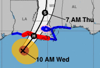
The 10 AM NHC advisory offers few surprises as they have keep the centerline track the same since the 4 AM update. I don't have much to offer since I have been ready since yesterday. What I do know is we really need the Recon (AF, NOAA) aircraft flying into these storms when the center is ill defined and there is no clear eye/center. Here's what I mean. I begin with some local humor that the Causeway Bridge had yesterday.
I'm seeing several swirls on the visible and Color Infrared satellite views. Sure, local radars give us a better indication where the center is, but it's the Recon data that pinpoints the center.
Even though it appears that center of Francine on radar is moving along the eastern side of the cone, it's so close to land that any wobbles this afternoon won't let south Louisiana & Mississippi escape this storm. Remember, Francine is a small, compact storm with hurricane force winds confined to the eyewall. Here's the NHC 10 AM update.
NHC has been consistent keeping the centerline track west of Morgan City. I still like the Graf model that Ch. 8 uses. It takes the centerline farther east over Cocodrie. It really doesn't matter since that won't change the impacts. This will mainly be a flooding rain event for NOLA with amounts likely between 6-12" this afternoon. IF you don't want you car damaged, move them up onto the neutral grounds. Stay off the streets, especially between 2-8 PM tonight. Zack Fradella has been highlighting the heavy band rotating around the eyewall that could be across most of us this afternoon.
Of some concern to me is the lightning firing off in the western part of the eyewall. Francine still has time to reach a Cat. 2 so let's not take it lightly. Make sure your children are not out wandering about this afternoon. Flying debris, falling trees will make it dangerous, possibly deadly to be outside. What I'll be watching for during the next couple of hours is a change in wind directions. IF the NHC track proves reality, our easterly winds should become SSE. IF we stay easterly or NNE, that would tell me the Graf model centerline might be reality with the center going over NOLA or just to our south.
Impacts won't change much except to shift the highest surge.
You can see the higher wave heights haven't reached our coast yet. I might try posting again this afternoon if my internet stays up.. Otherwise, we all know what's coming. We've been through this many times. Our rebuilt levee system has shown it can handle Cat. 1-3 storms. The main issues for most will be lost power and flooded streets and homes. Keep the prayer teams working until this storm is inland and moving away. Stay tuned!


No comments:
Post a Comment