It's obvious from satellite views that Helene is getting better organized and, based on Recon data, NHC has upgraded her to a Cat. 1 Hurricane. This has been expected, although some of Helene's circulation has been interacting with the Yucatan limiting development. Once her circulation moves away from land and over the warm Gulf, rapid intensification is expected. Helene is likely to make landfall as a Cat. 3 or 4 Hurricane. Let's look at the newest track.
On first glance, there are no major changes. However, note the slight westward trend since the 4 AM advisory. (top graphic)
In the top graphic (4 AM) the centerline tracks right over Crawfordville & Tallahassee. The middle view (10 AM) shifts that centerline about 20 miles to the west. Is that a big deal? No, but IF that trend continues, it INCREASES the dangers to the Florida beaches east of Destin and LESSENS the impacts for Florida's west coast. Since this is expected to be a powerful Cat. 3 or 4, you want to avoid being in the EYEWALL. As NHC pointed out in their discussion, the average track error at 36 hours out is 60 miles! So expect more shifting as Helene approaches the coast late Thursday. She is just entering the Gulf NE of Cancun.
As you can see on the satellite views, Helene is taking on the classic look of a major storm. The color view has storms now clustering around the center. Here's what she will likely look like by tomorrow morning.
This was Hurricane Beryl when she was a Cat. 5 approaching the Islands earlier this summer. I'm afraid that's what Helene will look like once she's away from land and over the loop current.
Wave heights are increasing and all models are tightly clustered on the Big Bend area. But as NHC points out, since Helene will become a large system, major impacts will occur well outside the cone to the right/east. Here are the predicted maximum surge heights on land.
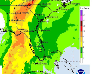
IF the track forecast doesn't have a late jog to the east/right, Max surge in Tampa Bay will be more like 3-5 feet. I hope everyone along Florida's west coast has stocked up and is prepared for the worst. I believe the worst will stay offshore based on current trends. heaviest rainfall may happen far north over the mountains of Georgia & Tennessee.
The surface cold front is coming and Helene will likely turn towards the front later on. NOLA will be on the dry side of this system. Any rainfall here will be along the frontal boundary late today & early Thursday. Good feel air is coming for this weekend. Next post coming after the 4 PM advisory. Traveling to Atlanta early on Friday will be difficult if going to the Saints game. Stay tuned!


No comments:
Post a Comment