
Have you ever remembered a hurricane season that has so many swirls that never develop? I haven't & I'm wondering what the Gurus who issued the early season "hyper-active" season numbers are thinking. Oh for sure they are saying the next 3-6 weeks are about to explode with activity, and they may be right. Sooner or later, Francine, Gordon & Helene will be named. But for today, all we have are swirls.


Of course we focus on the Gulf where NHC has made the Caribbean wave Invest 91-L that has entered the southern Gulf off the Yucatan. It is moving to the NW while what was Invest 90-L drifts to the south. Weather Bell's Joe Bastardi is mentioning these two lows may due a "Fujiwhara Effect" and rotate around a common center as they get closer to each other. Joe calls it "Competition, Combination then Intensification". Whatever, most models are developing a named storm in the Gulf by Tuesday or Wednesday and head it towards the upper Texas-south Louisiana coastline. Here's the model's landfall positions with the GFS on top, the Euro in the middle.


We would be on the "wet side", but the worst impacts would be to our west. Unless...that track position is farther to the east as the Euro AI (bottom) suggests. Hey, nothing is there to track yet and I'm somewhat confused by NHC letting go of Invest 90-L. Here's what I mean.


The arrow marks the exposed center of circulation of the well defined swirl. Look at the 50+ knot winds off the Texas coast plus wave heights 6-9'. To me, this probably could be called "sub-tropical Storm Francine" and is currently the stronger of the two Gulf lows. But NHC dropped Invest 90-L overnight and is now focused on Invest 91-L. Here are the Spaghetti plots.


The I don't like the early model projections, but remember, until Recon gets a fixed center to track, these Spaghetti Plots are just guesses. What could change the thinking? The upper Heat Dome is centered over the Rockies with a surface high over the Great lakes

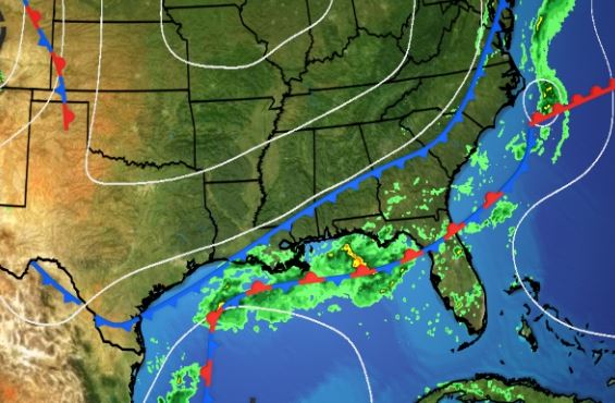
The old frontal boundary remains over the western and northern Gulf. Tropical systems like the follow paths of least resistance, which would be that old boundary. The WPC's rainfall projection continues to follow that thinking. In fact, it appears to me that the heaviest rainfall turns to the NE and then east towards AL/FL.


No surprise that FOX 8 has "Gulf Watch" on their 7 day. To ease anxiety, we have nothing to track YET. But from what I'm seeing, we will have a storm in the Gulf this coming week and it will have some impacts on Louisiana and the northern Gulf coasts. Pay attention time Gang. We don't need more rain as my 4 day total is 6.12".

One benefit of the clouds and showers are cooler temps. Let's gear up for the Saint's game tomorrow on FOX 8 at noon. Who Dat! Stay tuned!
No comments:
Post a Comment