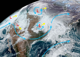
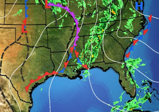
I've been talking about upper disturbances & surface boundaries/fronts for the past several days. Today we've seen two such boundaries move through, one this morning after daybreak and another this afternoon. The first this morning weakened as it approached SE Louisiana, but quickly ramped up sparking tornado warnings across the North Shore after dawn. That line is now east of Biloxi with a new line forming over us.
The current boundary appears to be stalled so some folks could see training rains of 1-2" this evening. As one upper low/disturbance lifts to the northeast, a stronger system is diving down out of the Rockies. That has SPC already sounding the alarms for severe storms on Saturday.
Their risk area has level 3 (enhanced) across the North Shore with level 2 (slight) over the South Shore. We should see a break over night before new storms re-fire during daytime heating on Saturday.
It's a complex surface weather map with us in the warm air sector. Dew points have risen to 70+ increasing fog potential plus tomorrow's severe threat. SPC has included a "hatched pattern" in the level 3 risk to our north.
They do that when they expect strong, long tracked tornadoes. Saturday morning should be quiet, but you need to make sure your FOX 8 weather app is ready to receive warnings tomorrow. Until the upper pattern shifts back to an east coast trough late next week, we'll stay Spring-like into next week.
Despite a couple of brief cool downs, December will end another month with above normal/average temperatures. Finally, I forgot to show you my poinsettia plant.
I'm told as long as I keep it away from any cold, this plant will keep growing into next summer. I don't know how they do it (grafting), but no longer are Poinsettias just red or white. Pay attention on Saturday as we could go under a tornado watch for the afternoon & evening hours. Stay tuned!


No comments:
Post a Comment