Yesterday began Meteorological Winter as the 2024 Hurricane season concluded the day before. All the early season predictions proved to be excessive, but the "experts" are calling Hurricane Season 2024 "hyper-active" since there were 18 named storms. Granted, it was above the normal 30 year average of 14 named storms, of which 11 became hurricanes and 5 major. But let's compare 2023 with 2024. Bruce Katz used this graphic Sunday morning on FOX 8 News.
2023 actually had 1 more named storm compared to 2024. But look at the difference in timing. 2023 already had 10 named storms by the end of August vs only 5 for 2024. Both years had active Septembers, but the real difference came this year during October into November. 7 storms were named in October & November in 2024 vs only 2 for 2023 with none in November. We all know it's about location and not the total numbers. Clearly, our recent cold fronts have cooled down the northern Gulf.
But another reason we don't see hurricanes in the Winter is the increased upper level westerly winds. We actually have 2 small swirls off the Texas coast but those strong upper winds will not allow any development. The upper pattern is locked in for the rest of this week with a ridge over the West and a trough across the Great Lakes.
Little surface disturbances called "clippers" dive down the upper trough bringing some snow and re-enforcing cold surges. The low off the West coast will bring a better chance for rain (maybe storms?) this weekend.
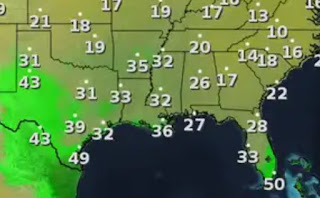
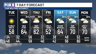
The next 2 days will stay dry with the good feel air, IF you're dressed for it. Note the dew points in the 30s even back to Houston. Some over-running showers will develop here Wednesday night into Thursday as temperatures briefly warm up. The weekend will see a stronger warm up ahead of the West Coast system.
I'm seeing 2 shots at rain coming. The first will be Thursday with the stronger one coming Sunday into Monday. The Weather Prediction Center's (WPC) rainfall outlook shows just that. The top graphic is the 3 day rain total focusing on 1-2" across the North Shore.
The bottom is the 5 day estimated totals with 3-5"+ staying to our north & west. So enjoy the next 2 dry days before we could get soggy later this week. Finally, the cold Arctic air will keep pouring southward out of Canada.
It's still 35-40 below zero in Alaska & western Canada. And to think we just started December! I always look for things to point out on satellite pictures. There was a huge fire burning north of Lake P. this afternoon.
Other smaller fires are over by Mobile Bay. What looks like fires south of Lake Pontchartrain is actually high thin cirrus clouds streaking in from the west. Made for a pretty sunset. Stay tuned!


No comments:
Post a Comment