This is a special morning update as the nation celebrates MLK Day & the Presidential Inauguration. We are preparing for the most snow any of us have seen (if born here) in our lifetime. While it will be a "FUN day" for many, it will also be a dangerous travel day. It should come as no surprise as that's what models have been predicting for days. We begin with the cold.
The 29 degrees was reached at 7 AM, but the 9 AM temps are still below freezing. I placed a glass of water outside & it froze. Even my bird bath fountain with running water froze! So we are deep into the cold air and any mention of being too warm for snow can be eliminated. Let's go through the timing & the predicted totals.
Zack had this graphic this morning clearly showing when you need to be sheltered in place tomorrow. Heaviest snow should fall between 9 AM & 2 PM. NOBODY should be on the roads Tuesday except emergency response (Police, Firemen, EMS etc) folks.
This will easily be the greatest snowfall since the Sugar Bowl storm of 62-63. It will be my greatest snow event since the great blizzard of Feb. 1978...but I lived in Dayton, Ohio back then! So does the NWS agree with the FOX 8 totals? Pretty much.
I did notice they have both sides of the Lake with 4-6" favoring neither the north or south sides. However, they do believe the North Shore has higher chances for the heaviest amounts. Not sure I agree with that thinking since drier air will be filtering down from the north.
They do have a great web site to visit for all you weather geeks wanting more information. So let me describe the set up.
The main Polar Vortex is up over Hudson Bay in Canada with a straight shot of Arctic air flowing into the lower 48. There is a weak disturbance rotating around the upper trough in Colorado that will trigger a Gulf Low tonight & tomorrow. So the table is set as we are deep into the bitter cold and a low will form well south of our coast. Here's the surface map for Tuesday morning.
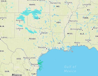
I thought this headline from our local NWS office says it all. The key word for me is DISRUPTIVE! Light snow is starting to show up on radar NW of Dallas.
With such low dew points, once snow starts to fall, a process called "evaporative cooling" will drop temps to below freezing keeping most precipitation all snow. Only extreme south Texas is above freezing with San Antonio at 26.
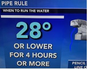
After the snow, cold temperatures will be the concern for Wednesday & Thursday mornings. Remember the "pipe rule".
My house in Metairie dropped to 29 this morning and I did NOT run any water. No need, but I could tell the water pressure was lower so many of you were running water. Only drip water when it is necessary or water pressure will get so low our firefighters will have no pressure to fight any fires. We will be above freezing all day until well after dark. No need to run water until you go to sleep. Another update after 4 PM. Stay tuned!


No comments:
Post a Comment