I've been enjoying watching TWC and our local Weathercasters trying to figure out what will happen next week. I don't mind them showing all the different solutions from the computer models, but I would like to know "What do they think?" Just saying "it's too soon to know" or "models are flip-flopping run to run" is not good enough. Show me what you're thinking. Nicondra & Bruce did a good job of showing the uncertainties with next week. However, I guess that's why my FB followers keep increasing as you like the way I story tell? So let's begin with what we know and it starts with why is California & the West Coast so dry? After all, January is, historically their wettest month. But not in this La Nina year.
The southern sub-tropical jet steam/storm track remains weak with the main storm track over the Pacific staying well north of the Hawaiian Islands (yellow circle). This keeps a big upper ridge over the West coast resulting in clear skies and no rain.
That flow has brought a surge of milder Pacific air to Alaska & much of Canada with the super cold (20-30 below) bottled up over northeastern Canada.
Even though the upper flow is coming down out of Canada, the real frigid air isn't there yet. So where is the super cold? It's in Russia & Siberia (50-55 below zero!)
Alaska has turned colder as the blow zero temps have returned. Let's watch and see if the super cold crosses the North Pole as the models indicate. Here's the satellite view & model forecast beginning with today.
There is a weak dip heading towards the Great Lakes, but here's why we need to pay attention for next week.
Look how a lobe of the Polar Vortex deepens over the Great Lakes allowing a north to south flow into the lower 48. Yikes! If the model prove accurate, we will see a hard freeze for the North Shore & a light to moderate freeze south. But what about snow? The GFS says no while the Canadian & Euro say yeah. This is the forecast for next Tuesday PM.
The bottom is the GFS, keeping the low way down over the Gulf. How can models be so different? Remember, models are for GUIDANCE. It's up to the forecaster to determine which model appears more likely. With the lack of any super cold covering southern Canada RIGHT NOW, I'd say the GFS is probably the more likely solution. Watch those temperatures up in Alaska and southern Canada. Regardless, I plan on working in my yard on Friday & Saturday before the cold arrives. I'm pretty certain a freeze is coming. Snow?
Those North Shore lows could easily drop into the teens IF the models are correct on the cold.
In the short term, a weak Gulf system will pass mainly to our south over night spreading some light rains over us. Rains should be gone by dawn with sunshine returning.
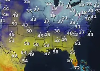
Notice there is no cold air around us. In fact, Denver is 40+ with 40s up into the Dakotas & Montana. It's go to get cold up north first. Finally, Thursday night is my wife's Art Show. It's at Degas Gallery 3909 Magazine Street from 6-8 PM. Here are some my favorite 3-D pieces of her artwork.
The antlers & prayer sticks are just a few of her 3-D creations. You can see them all on her website, www.brendabreckart.com. You can see & purchase her paintings at Degas Gallery tomorrow night. Hope to see some of you there. Stay tuned!


.jpg)


No comments:
Post a Comment