Officially, in the record book, today's low will be 33 at MSY. I have pointed out numerous times that, since the new airport was built, the temperature reading at MSY has read several degrees too high and not representative of metro NOLA. Here's an example that shows that. I have a small birdbath in my backyard well away from my house.
As you can see, there is a frozen column of water coming from the middle section to the bottom. The remaining water in the base was frozen solid. But how could that be IF the low was only 33? My thermometer read 31 degrees at 7 AM suggesting that perhaps my low was 29-30 for the fountain to freeze like that. My point being...since NWS eliminated the Audubon Park weather station several years back, we have no reliable site for where most of the city lives. The other issue is this. At what temperatures do we need to worry about our pipes freezing? For years, I used the "Pipe Rule" of 28 degrees. But yesterday, another Channel (see the logo) came out with this.
So who is right? Let me quickly explain where the "Pipe Rule" originated. I arrived here in 1978, but my first real freeze was in December of 1983. My house was a single-story structure on a slab in the Bridgedale section of Metairie. I awoke to a busted pipe in an outer wall on the back of the house. Fortunately, a master plumber (Mickey Scholl) lived across the street. He repaired the pipe and informed me to "run the water" next time temperatures dropped to 28 or below. It was his 40+ years of hands-on experience in dealing with busted pipes that determined that temperature. It has served me well since I never had another broken pipe, even during the Great Christmas Freeze of Dec. 1989. So my question is this. IF you choose to follow the advice from the other channel, will they cover the costs of repairs IF you have a pipe burst at 28, 26, or 24 degrees? Exactly. Stick with the advice from an experienced plumber instead of an "engineering study" probably done in Colorado?!!! So on to this weekend of parades.
A blanket of clouds is spreading back over us and that will keep us much milder (less cold) tonight. I have not uncovered my plants nor moved any pots from my heated shed. This milder/warmer trend is occurring due to a change in the upper air pattern that has returned to a more west-to-east flow.
Our weekend rain threat will come from a little feature coming across Southern California. It doesn't show up unless you switch to the Water Vapor channel. Low clouds have surged back off the Gulf, but the warm-up is painfully slow.
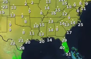
An Arctic air mass is very dense/heavy cold air that doesn't move out quickly. 30s remain across south Texas and we will again struggle to top 50 here tomorrow and Sunday.
The real warm-up won't arrive until Monday afternoon so this weekend is still heavy coat weather. Any showers Saturday will be light & later in the day with Sunday being the main rain day from that western disturbance. This is when we want the models to be wrong! Don't rain on my parade! Stay tuned!


No comments:
Post a Comment