
Part of what I'm allowed to do on my blog site is to observe. I can express my opinion on what I'm seeing. The past 2 days I dumped on the computer models for a colossal weekend bust that cost some folks thousands of dollars. My main beef was with the idea of "warning" us 4,5, & 6 days ahead of time that severe weather might come. Reality has taught me there is great UNCERTAINTY that far ahead of the event. However, 1-2 days before, accuracy is much greater. This morning's storms were accurately predicted on last night's model runs with the timing over NOLA between 6-10 AM. Buda, boom as that's what happened. We begin with radar at 5 AM


By 9 AM (bottom view) that line was approaching Hammond/Ponchatoula with tornado warnings issued by NWS. Zack stayed on the air non-stop, tracking the Velocity signature on VIPIR along with a debris indication. Fortunately, only some trees were blown down. By 9 AM the line reached the South Shore.


Rainfall rates were intense, but the line kept moving and totals were generally 1-2". Skies started clearing after noon as we look to the next system coming out of the Rockies.


I'm using the Water Vapor channel to point out the disturbances I see. What we had this morning is already moving off the East Coast with a weak dip over the Great Lakes. The main upper low is off the West Coast sending spikes of energy around it. Where does that upper low go? The GFS model takes it far to our north. We begin with the upper flow graphic with today on top.


The upper energy stays far to our north and SPC indicates that on their severe outlook for tomorrow & Wednesday.


But unlike this morning's storms, SPC keeps any severe risk away from us based on the GFS model forecast. Here's the model guidance for Thursday & Friday.

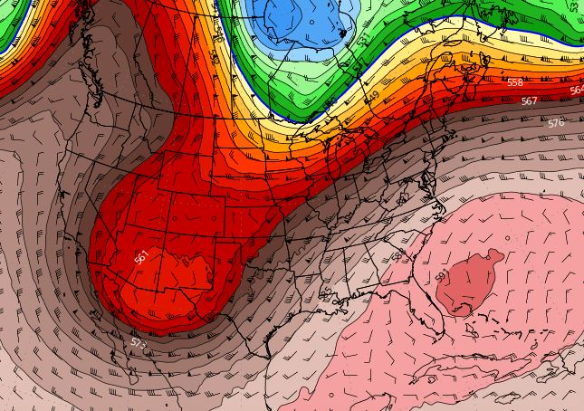
The upper low lifts up into Canada with a strong upper ridge building westward over Florida. That will stall any fronts and keep us flirting with record warmth. It also means the SW upper flow will create training of storms resulting in heavy rainfall.
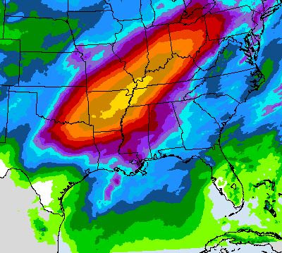
This is the 7-day rain total forecast with that yellow/orange bullseye meaning as much as 12-18" will dump on Arkansas into Kentucky. The frontal boundary will be the focus with winter-like air to the north and almost summer-like to the south. Unfortunately, the north over Louisiana has already stalled and will dissipate or retreat back to the north on Tuesday.


D.C was in the 80s today, while north of the front locations stayed in the 40s. We're almost hot for the next 4-5 days.

We're not done with cold fronts as I see several coming next week. Of course, a cold front in April is far different than one in Jan/Feb. What we want now is just fronts that bring drier air. Those 70+ dew points don't feel nice plus my allergies go nuts when it gets that humid. Finally, Yep, 2 months from tomorrow...

I know you don't want to be reminded! Stay tuned!
No comments:
Post a Comment