Reading your comments, I share your frustration in how wrong yesterday's model guidance turned out. We were alerted days in advance that Saturday would be awful, with several events cancelling ahead of time. Even yesterday, as late as the 5 PM weathercasts, models kept predicting all this rain that wasn't there. WPC/NWS put out a graphic that indicated a level 3 out of 4 (pretty confident) for flooding rainfall.
I shared my thoughts as to why I didn't see that happening by circling on satellite pic where the current motion was taking the storms. At least one local weathercaster did point out that the overhyped forecast model didn't initialize correctly. That's all I'm asking the local weathercasters to do...storytell. Don't show the models UNLESS you have the radar BEFORE the models. If the current radar echoes don't match the model initial view, point out why you might not believe the model solution. If you keep crying out wolf and the wolf never comes, all credibility is gone. Enough of me venting; let's move on to today. I don't want my local weathercaster just standing in front of the satellite loop waving their arms but pointing nothing out.
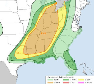
The middle view is the water vapor channel where I marked the features I see. We do have some nearby T-Storms just to our east along the MS/AL Gulf coast. It appears that is caused by a splitting of the upper winds. Another weak feature is over Texas, but the strongest energy is up with a low over Iowa. I'm not sure why SPC has such a broad/wide area for severe potential today.
They shift that area to the east and south for Monday placing us in a level 2 (slight) severe risk. It's probably because another upper feature is coming across the Rockies today.
Just my opinion, but it appears the upper energy will again be to our north and east. However, that doesn't mean the severe risk is zero. Certainly, there is a front that should cause uplift to produce some storms tomorrow. In addition, there is quite a temperature contrast.
Note the surge of high dew points (60+) is all the way up to Chicago where they're 70. Just west of them it's in the 30s & 40s. Burrr!!! Locally, we have some storms nearby.
Motion is SW to NE so they should stay away from the South Shore. However, temps have jumped into the middle 80s & that might bubble up some showers south of Lake P.
So our one problem day will be tomorrow. Let's keep up with the forecast in case things go downhill. Stay tuned!


No comments:
Post a Comment