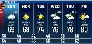
This will be a brief update regarding the low risk for severe weather this weekend. SPC has NOT increased the level one (marginal) threat as the upper dynamics are not as strong as our last system on Mardi Gras. It also appears the best rain chances will come as the upper system reaches us on Sunday morning.
You can see the huge temperature difference between Dallas (49) and Houston (83). Over Louisiana, it's more of a dew points difference with the 40s north of the boundary and 60s south. Today heavy storms are across north Louisiana.
I expect more showers to fire along the dew point/warm frontal boundary later tonight with along band around daybreak on Sunday as some cooler and drier air spreads in during the afternoon.
One other thing, before you go to sleep, set your clocks ahead one hour (Spring forward) tonight as we return to Daylight Savings Time at 2 AM. Stay tuned!


No comments:
Post a Comment