The National Hurricane Conference was in town this past weekend without most of the government speakers due to budget freezes. However, one long time hurricane expert, Brian Norcross was here. Brian is the former Miami meteorologist who became famous during Hurricane Andrew back in 1992. He is now with FOX Weather nationally and they are doing a hurricane special looking back on the 20th anniversary of Katrina. I am honored to be included in that special. Here are 3 hurricane forecasters with many years of experience.
Yeah, that's the youngster Bruce Katz on the right with the retired little fella in the middle. As we begin Easter weekend with lots of outside events, our weather is getting more humid, but should stay mostly dry as we're under the upper ridge with the trough once again over the Rockies.
Circling the upper ridge are strong storms right where SPC has their level 2 severe risk outlook. That does not shift any as we head into the weekend.
The top graphic is Friday's severe outlook with the bottom valid for Saturday. So it appears all of the weather will go up and over the Upper ridge.
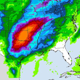
You can see the effect of the upper ridge on the surface temperature plot. 20s & 30s over the Rockies while the warm sector is in the 70s, 80s & 90s. The battleground is set for some heavy rainfall the next 4-7 days.
Early next week, a few showers could show up, but the front will be weakening and losing its upper support. Hopefully, the heaviest rainfall stays back over Oklahoma and Kansas as we have a high, muddy Mississippi River. Here's how it looks on the daylight satellite view.
The crest reaches us on April 27th. A lot of muddy water is seeping through the Bonnet Carre Spillway. The Army Corps might have to do a partial opening, but that decision is yet to be made. Stay tuned!


.jpg)

No comments:
Post a Comment