Saturday, August 31, 2019

Dorian Stays Just Below Cat. 5...

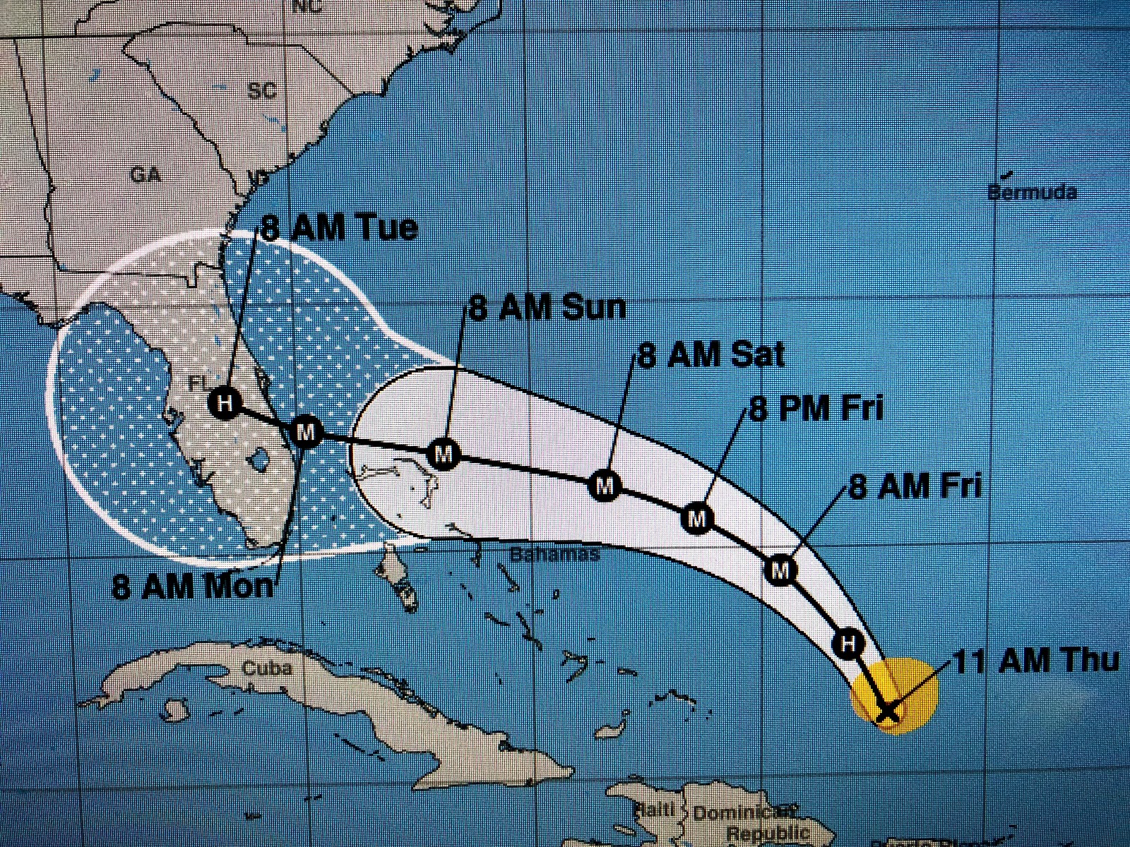
Satellite loops show a classic major hurricane moving slowly edging closer to Florida. He has NOT yet started the expected turn to the north, however, his forward speed is slower hinting the change is coming soon. To be on the safe side, NHC issued Tropical Storm Watches for the northern east coast of Florida late this afternoon. The 10 pm advisory should not contain any surprises.  Since Dorian will be crossing the Gulf Stream Monday, don’t be surprised to see him briefly make Cat. 5.  I’ll still be watching for that north turn tomorrow, but NHC seems confident it will happen.

The system over the southern Gulf is now given a 30% chance for development but should stay over the southern Gulf.  Yet another system off of Africa has been upped to 60% chance to develop. Welcome September, the most active month for Tropical activity. Stay tuned.

Radical Shift in Track...


During my 4+ decades tracking hurricanes, I’ve seen how conservative the NHC is in making major track changes. They hate to flip-flop with each new model run so usually they just “tweak” the centerline track position. Not overnight.  I mentioned in my last post 3 scenarios, one being a shift to the east BEFORE Dorian reaches FLA.  NHC now has that scenario. Does it mean FLA. is spared?  Not yet since much of the state is still in the cone. Plus, the turn hasn’t happened yet! (Remember mass + momentum equation). Dorian is nearing Cat. 5 and will be harder to make radical turn. But that’s what the models say will happen. Sure the threat has lessened for FLA. but it’s not zero.  He has a spectacular satellite presentation and is a beast. Let’s hope the model trends prove correct. Oh by the way, NHC is giving a small swirl north of Cuba a 20% chance for development over the western Gulf next week. Geez, stay tuned!


Friday, August 30, 2019

The Beast From The East...


Based on satellite loops and recon data, Hurricane Dorian could be a Cat. 4 soon. The Infrared satellite presentation is a classic major hurricane signature donut hole. It is very symmetric and will cause great damage wherever it makes landfall. Florida’s only hope is it turns to the north before it reaches the coast(unlikely) on Monday & Tuesday.  Unless there is a radical shift in model guidance, the NHC track keeps the worst north of the “Gold Coast” (west Palm-Miami), but that could still change.  We’ll have higher confidence by midday on Saturday where the greatest danger and worst of Dorian will hit. Regardless of landfall, all of Florida’s economy will suffer a big hit as this comes during a holiday weekend. All those not impacted can just watch and pray.  Stay tuned!

Dorian Making Expected Turn as Cat. 3

Hurricane Dorian is behaving as expected and about the only changes from yesterday are 1) the centerline track is farther southward (now near Jupiter) and 2) days 4 & 5 positions have shifted to north of Orlando.  If you didn't follow the centerline track you wouldn't know that since the error cone still covers all of Florida from Key West to Georgia.    Unless there is a radical model shift, I expect there will only be minor tweaks made to future NHC tracks.   The real worry remains for the east coast of Florida for winds and surge with much of the state under the potential for massive heavy rainfall due to Dorian slowing down.  Note the forward speed has decreased from 13 to 10 mph and further slowing is expected.  The Panhandle looks to be the only part of the state that should avoid any major impacts.  Aside from Dorian's jog east of Puerto Rico, he has not thrown us any curves.  As mentioned in previous posts, there is still high UNCERTAINTY beyond 3 days.  Could Dorian reach the coast and turn to the SW?   Could he turn to the north BEFORE reaching the coast?  Could he reach the coast and keep going to the west?   The answer to those questions is sure, but models are not showing that right now.  Again, watch the forward speed and the center line track that has shifted from near Melbourne yesterday to near Jupiter today. Will that southward trend continue?  Watch the surface pressure (currently 970 mb) since, if it keeps lowering that means wind speeds must increase.  Dorian remains a Florida storm with no impacts for Louisiana or Mississippi right now. Will update again if there are any major changes.  Enjoy your Holiday weekend and stay tuned!

Thursday, August 29, 2019

Dorian Approaching Major Hurricane Status...


Again I'm waiting on new track at 10 PM.  Here's what I'm seeing.  Recon is finding lower pressure which usually means higher wind speeds.  The IR (infrared) satellite loop is starting to see an eye pop out with new storms firing around center.   That was supposed to happen as intensity models bring Dorian to a Cat. 4 (130 MPH+) before landfall.    But where will landfall be?   Do we believe the models?  Let's go back to Hurricane Harvey in 2017.  Models brought it to lower Texas coast as a Cat. 4 and moved it inland and slowed it down with a loop indicating super heavy rain totals.  Models totally verified.  Now to Dorian.  Models bring Dorian to Florida coast as a Cat. 4 and then slow it down.  there are some differences in landfall, but the slowing down means super heavy rain totals are coming for much of Florida and then Georgia & the Carolinas.  I would be shocked to see a radical shift in the 10 PM NHC track.  Also, several models now say another system will form over the SW Gulf while Dorian nears Florida.  Geez, nothing to worry about but lots to talk about.   Several systems are predicted to develop way out in the Atlantic next week.  Just what this time of year considers "normal".

OK, it's in, the latest from NHC and the track is the same stalling the storm between Lakeland & Orlando by next Tuesday.   Yikes, we will have a long time to watch this system.  I don't have much to add except I noticed the error cone still covers all of Florida, which tells me confidence is low at days 4 & 5 and there remains great UNCERTAINTY in the final landfall.  Where that happens means a great deal on who gets the strongest winds and heaviest rains.  Right now, Florida and the SE coastal states are the ones under the gun.  This will be a long waiting game for many.  There are NO indications Dorian will ever be a concern for us. Stay tuned!  Next update probably Friday PM.

Higher Intensity, Same Track...


Since the 10 PM update last night, NHC (National Hurricane Center) hasn't changed their forecast track at all bringing the centerline just south of Melbourne and inland between Lakeland & Orlando.  What has changed is the predicted intensity forecast, from 115 MPH (Cat. 3) last night to 130+ (Cat 4)  today.  Regardless, this will be a major Hurricane with widespread damage (especially coastal) along his path IF that forecast proves reality.  I'm somewhat confused by the uptick in intensity since the MJO (Madden-Julian Oscillation ) is in an unfavorable (sinking air) phase.  We'll see.   The bend in the track to the west will be caused by a blocking high to the north of Dorian with the Euro model bringing his eyewall farther to the south of the NHC centerline, while the new American (GFS) model has landfall north of the NHC centerline.   Almost all models now have a radical northward turn once Dorian moves inland and slow it down keeping it out of the Gulf.  I remember from physics class an equation regarding mass & momentum that basically says a larger mass (hurricane) with a faster forward speed is harder to turn/change course.  So what I want you to watch for during the next 2-3 days is the forward speed, currently 13 mph.  If it slows down, the greater the chance for that northward turn, which is what we want.   What you should take away from the possible forecast track above is the cone of error covers the whole state of Florida.  Translation?  the greatest danger is central Florida, but there is still great UNCERTAINTY beyond day 3.  By midday Saturday, models should be locked in on where landfall is most likely.  For those of you going to the Alabama/Florida beaches this Labor Day weekend, no need to change plans.  However, if you are supposed to go to Orlando to any of the theme parks, you will probably have to cancel as the current tracks all impact Orlando to the extent they will have to close the Parks.  Let's give it another day, but right now it doesn't look good.  Those of you with friends & relatives in Florida remember, unless they are on the coast, they have some inland elevation.  Still, if the predicted intensity verifies, 100 MPH+ gusts could go as far inland as Orlando.    Next update is at 4 pm and little should change in NHC's thinking.  I'll post later this evening.  Stay tuned!

Wednesday, August 28, 2019

Dorian Getting Stronger...


I'm writing this waiting for the next update at 10 pm.  What I'm seeing on satellite loops is a slowly strengthening system pulling away from Puerto Rico heading northward to the open, warm waters of the Atlantic.  Recon is finding pressure drops continuing and the next advisory probably will increase the winds to 85-90 mph.  David Bernard gave a very understandable explanation of the uncertainties involved in the future path of Dorian at 9 PM.  I would suspect NHC will not have any major changes to their track forecast as they don't want to start flip-flopping with each model run.   As I previously mentioned, the northern Gulf is not totally "out of the woods" with this storm, although the chances for us being impacted remain very slim.  OK, the 10 pm update is in and winds are up to 85 mph and the track is essentially the same as before, which is good for us as NHC did not continue the southward shift in the track.  Let's hope the expected blocking high to the north is not as strong and Dorian can take a more northern path keeping it out of the Gulf.  Watch that centerline shift update to update as it will give you the thinking of the forecasters at NHC.  We want that northern shift  and not the southern one.  Way too soon to know which one wins out.  Stay tuned!

A Real Test of 2 Models...


Recall yesterday's morning's post when I talked about the Centerline track of NHC talking Dorian over the extreme west edge of Puerto Rico and the eastern edge of the Dominican Republic.  Well, their track was not close as Dorian's real track took him EAST of Puerto Rico sparing the Island of the heaviest rains & winds.  The Virgin Islands were not so lucky as they received wind gusts to 90+ mph.  The track error was over 100 miles at 48 hours, far greater than normal (50-60).  One thing that hasn't changed in 2 days is the landfall along Florida's east coast.  In the recent past, the Euro model has been the more accurate model, far better than the old GFS (American).  However, this year we have a new GFS model that is SUPPOSED to be better.   We better hope so because the Euro model is bringing Dorian way farther to the south and then into the NE Gulf with landfall near Destin next Wednesday.  Just watching David and he showed the newest GFS model run that mirrors the Euro and is much farther south of its previous run.  Previously the GFS took Dorian closer to Jacksonville and never reaching the NE Gulf.  With this new info NHC shifted their centerline track from north of Orlando to south of Orlando.   Let's see if that disturbing trend continues on their next update tonight at 10 PM.  Bottom line, the northern Gulf is not fully out of danger from Dorian as the Hurricane of 1947 & Hurricane Andrew (1992)  took tracks over southern Florida and ended up impacting New Orleans.   If you have plans for the Gulf beaches this Labor Day weekend you should not cancel, but keep up with the latest daily updates.   IF the Euro proves correct, you'll have plenty of time to flee back to NOLA.  Here's my take...there is a history of storms that come across or near Puerto Rico and then bend/turn back to the west.  Most of them became major (at. 3+) Hurricanes and NHC is predicting just that.  What we would like to see is a track on the north side of the cone.  What we don't want is the current trend of shifting the centerline farther and farther to the south.  That would increase the chances that Dorian would impact the northern Gulf, including us.   The pay attention day will come on Saturday as, by then, the computer models will be locked into tracking a major storm, which NHC is extremely good at recently.  For now we watch and track.

Locally, a weak front will bring us much drier air for Thursday, Friday & Saturday before we're back in the muggies and showers by Sunday  IF Dorian stays to our east, we could dry out again for next week.  Stay tuned!

Tuesday, August 27, 2019

Dorian Entering Eastern Caribbean...


This is an early AM post as I'm fishing this PM.   Overnight, not much change with Dorian nor in the thinking of NHC.  They shifted the centerline track slightly to the north and that will become more important 2-3 days from now.  IF Dorian survives the mountains of the Dominican Republic and regains strength over the Bahamas, we want that centerline track to stay north of Lake Okeechobee if he tracks over Florida towards the NE Gulf.   That would limit the time in the Gulf to regain strength. We don't want to see the more southern track of the cone as that brings Dorian on an Andrew like path towards south Florida.   Regardless, IF Dorian were to head towards us, we're talking impacts NEXT Tuesday & Wednesday.      That is a long way out with plenty of time to watch him.

Locally, we have an early Fall preview coming as a cold front will sweep off our coast Wednesday night into Thursday.  Much drier air will filter in behind it allowing for nights to cool into the 60s on the North Shore.  Some storms could bubble up during daytime heating today & tomorrow with a line of storms possible ahead of the front Wednesday PM.  Stay tuned!

Monday, August 26, 2019

The Value of the Centerline Track...

Several years ago at one of the Hurricane Conferences, a "social scientist" gave a talk about how the public often is confused by the NHC centerline track forecast.  He claimed folks thought if the centerline moved away from them, they were out of danger despite still being in the cone of error.  The suggestion was to drop the centerline and just use the cone.   Many people jumped on that bandwagon, but I was not one of them.  For 38+ years I educated my viewers on the value of the centerline as, by following its movement, one can determine the "trending" (which way the track forecast is moving) that NHC is thinking.   With Tropical Storm Dorian crossing very near Barbados tonight, I'm looking at where NHC is trending that centerline.  On the latest advisory (4 PM) they didn't change it at all keeping it right over western Puerto Rico & the Dominican Republic and then into the Bahamas.   If it continues, the centerline heads it right for Miami.  That's why it's so important to follow it.  Just looking at the cone often isn't much help, especially if the centerline shift is slight.    I'll be watching that closely over the next several days and you can too.  Just toggle the "on" button on the NHC site to include the track.   Our worry time with Dorian won't happen (if ever) until early next week.    TD # 6 formed this afternoon, but wind shear will keep any development a struggle.  It'll stay way off the East Coast of the U.S.

Locally, T-Storms blew up right over the South Shore between 3-5 PM dumping 2-4+" of rain in less than 2 hours.  More flooding happened as the intensity overwhelmed the pumping capacity once again.   We could see some more storms bubble up on Tuesday and even more on Wednesday as a cold front approaches.  It will give us an early Fall preview for Thursday and Friday before summer returns by Saturday & Sunday.   Stay tuned!

We Are So Much Better Prepared...


Today's New Orleans Advocate had a good story regarding how the National Hurricane Center has improved their accuracy over the past 20-30 years to where their track forecasts at 3 days is as good as their old 5 day forecast.   Which got me thinking of how we use to track hurricanes when I entered the business in 1971.    We had no GOES Satellites providing us with smooth loops to see how a storm was developing.  We had to piece together multiple passes of the Polar orbiting satellite to give us ONE picture of what a hurricane looked like from space.  Looking back, kinda primitive, but back then we were thrilled!  Yes we did have the Recon aircraft (Hurricane Hunters) from Keesler AFB along with a stray ship report or two, but that was it.    No computer models to help us predict the track, just the skill of the individuals down at the NHC (National Hurricane Center).  Remember how each television station offered their own tracking map for viewers to plot coordinates?   Geez, now it's automatically done and plotted out in the future.  No more tracking maps!  Thankfully technology has made forecasts more accurate and understandable.   Computer graphics (which came out in the late 70s) now show impacts from storm surge, arrival of tropical storm forecast winds and where the greatest probabilities are regarding landfall.  Unfortunately, what most TV broadcasters don't do is give their opinion anymore.    I still believe some folks want to know what does Bob think? or David? or Bruce?

Last night I indicated it appeared to me the heavy rains were staying offshore and indeed they did.  The computer models were not very accurate.   We are getting some passing storms this afternoon, but the bulk of the really bad weather is to our north and east.  Tuesday into Wednesday will be mostly dry before a round of storms plows through ahead of a cold front Wednesday night into Thursday.  Much drier air will follow the front for this weekend.

Updating the Tropics...Erin hasn't been named yet, but the daylight (visible) satellite loop has a well defined circulation way east of the Carolina Coast.  Her circulation remains exposed (no storms around center) due to west wind shear,  but it's only a matter of time before the shear weakens and storms wrap around the circulation.  Of greater interest is Tropical Storm Dorian approaching Barbados this afternoon.  NHC still believes he'll become a hurricane once in the eastern Caribbean and take a track more to the NW in time.  RIGHT NOW, he continues almost due west , which would take him across the southern Caribbean which has an unfavorable environment for development.  NHC has Dorian nipping the western coast of Puerto Rico and the eastern coast of the Dominican Republic moving into the Bahamas and then towards Florida.  That is still over a week away and lots can happen to change that track.   Several long range models bring Dorian into the Eastern Gulf for the middle of NEXT week.  You already know my feelings on the accuracy of models 10-14 days out so let's not join the hype machine that many bloggers treasure.   For now, chances for Dorian ever reaching the Gulf and being our problem seem slim, but not zero.   It's what we do every Labor Day weekend...track Tropical Storms and/or hurricanes somewhere.    It's not the "new normal", it's just the typical peak of tropical activity.  Stay tuned!

Sunday, August 25, 2019

Heaviest Rains Staying Offshore...

All day heavy rains have tried to move inland along the Louisiana coast but they quickly weaken as they try to head north.  NWS still has a Flash Flood Watch up as there is the potential for 2-3" rain totals through Monday morning.  However, what I'm seeing is the greatest lightning strikes and colder cloud tops shifting due east and not heading inland.  There is an upper swirl/disturbance moving across Arkansas tonight and that might be the trigger for some storms after midnight?   However, once that passes us by, I expect Monday PM to become Pt. Sunny with only a stray shower or two.  Tuesday looks mainly dry before another round of storms arrives late Wednesday ahead of a cold front that should dry us out for late week.

Invest 98L has yet to show any development and, if it does, will be way off the Carolina coasts Tuesday & Wednesday.  Tropical Storm Dorian is slowly getting stronger and NHC brings it briefly to a Cat. 1 on Wednesday south of Puerto Rico.  On their current projected path, Dorian moves over the tall (10,000'+) mountains of the Dominican Republic weakening it back to a depression.   After that, it should make the turn east of Florida, but that turn is over a week away and lots could happen to change the NHC track.  Of course the bloggers will latch on to any computer model that on day 10 says Dorian will be in the Gulf.   Having been in this business for 40 1/2 decades, I know not to jump on anything out beyond 5 days, let alone 10-14.     Let's just stay away of Dorian, especially if you have weekend plans taking you to the east coast.  Stay tuned!

North Central Gulf Stays Stormy...

There remains a disorganized cluster of T-Storms over the north central Gulf, but NHC dropped this area from their probability for development.   I can no longer find the swirls that were apparent on yesterday's satellite loops and even on radar, only a hints of a weak rotation is offshore well south of Lafayette.  What does show up nicely are storms diving down from the Plains with an upper trough.  That trough should pick up the disturbed weather along our coast and bring it through us over night and tomorrow morning.  That means much of Sunday should just be cloudy with a few stray showers.  IF we do get heavy rains, they won't come until over night into early on Monday.  Tuesday looks OK before that front I've mentioned for later next week approaches with some storms on Wednesday.  Drier air filters in behind that front for Friday-Sunday.

Invest 98L off the east coast hasn't done much but is still expected to become Erin early next week.  She will head out into the open waters of the Atlantic.  Tropical Storm Dorian is taking a more southern track towards the Caribbean where it is likely to encounter dry & sinking air.  That should limit or kill off any future development.  NHC still is calling for him to become a Hurricane and eventually make the turn to the north before reaching the U.S.   Even IF Dorian could maintain itself across the Caribbean and into the Gulf, the time frame would be late NEXT weekend into next week IF we were to get any impacts.  Chances for that happening are slim & none, but we will have many days to watch and see.   Enjoy your Sunday afternoon.   Stay tuned!

Saturday, August 24, 2019

Dorian Forms Way Out in Atlantic...

The season's 4th named storm (Dorian) was named this afternoon.   He is predicted to become a Hurricane by early next week on a possible track thru the northern Leeward Islands towards Puerto Rico & Hispaniola.  It is way too soon to speculate whether Dorian turns to the north & misses the U.S. or stays on a more southern track into the Gulf.  Based on what's happened so far this summer, the odds greatly favor the turn to the north track RIGHT NOW.  But let's focus closer to home before we think about other systems. 

NHC finally is talking about the cluster of storms over the NW Gulf giving it a very small (10%) chance for development.  What I'm seeing on the visible(daylight) satellite loop are several swirls(vortices/rotations) with no pattern of becoming better organized.  One swirl is inland NW of Lake Charles moving into eastern Texas, another on radar is just south of Lake Charles with the much bigger swirl offshore farther to the south.  That's where the heavier storms are 100-150 miles off our coast.  My concern is IF the larger swirl becomes the real center, we are on the "wet side" of whatever forms so we'll need to pay attention Sunday and Monday for potential flooding rainfall.   During late August & early September, tropical systems move very slowly (Harvey 2017) resulting in really high rain totals.  Until we start to get into late September & October,  the slow movement of storms is to be expected.   Whether it gets a name or not, the main impacts will be heavy rainfall.

Invest 98L has the same situation as there are several small rotations on the visible loop.  One is SW of Lake Okeechobee over land with a bigger swirl over the northern Bahamas.   NHC expects this system to slowly become better organized with a 90% chance of becoming Tropical Storm Erin by Sunday.   The projected track keeps her well east of the Carolina coast.

So our concerns should be # 1, the system over the NW Gulf and # 2, Dorian staying on a southern track for next week.  We'll have plenty of time to watch for that so focus on the Gulf this weekend. Stay tuned!

Friday, August 23, 2019

Good Bye Old Friend, My Old Friend...


The Nancy Parker Boyd memorial Service was this morning and will be rebroadcast tonight on FOX 8 between 8-10 PM.  .Her husband Glynn sang 3 long songs to her and it was both heart warming & heart breaking at the same time.  It was a fine tribute to a great long story.   If you're able, you can help out by contributing to the Nancy Parker Education Fund at any Gulf Coast Bank & Trust.

The area of disturbed weather remains over the western & northern Gulf.  I can not find any upper low on the daylight satellite loop and it appears a cluster of storms is gathering east of Brownsville.   NHC is not talking about it yet and no models show development.   We still expect some heavy rains at times over us for Saturday & Sunday.   Invest 98L is now expected (90%) to develop off the Carolina coast this weekend.  The satellite and radar loops show a circulation half over land near Miami so little development is expected until this system gets back over the Gulf stream late Saturday into Sunday.  It will have no impacts for the northern Gulf.    Another system (Invest 99L) is over the central Atlantic and NHC now thinks it could become Erin (50%) during the next 2-3 days.  Satellite loops have a swirl of low level clouds with some storms around it.  It could approach the Leeward Islands in 2-3 days.  Since it's that far out, too soon to even worry about it.

Our focus will stay with the Gulf disturbance since that is nearer home.  Just keep up on the weather over the weekend.   Models still show some kind of front nearing us next week.  Stay tuned!

Thursday, August 22, 2019

Dorian Likely, but not in Gulf...

NHC has increased the probabilities for development along Florida's east coast from 20% to 50% in 5 days.  Visible satellite loops had a weak swirl between Miami & Nassau this afternoon and that is confirmed on tonight's radar loop.   This weak low will be along the east coast of Florida the next 2 days with only slow development.  Once it clears land and gets over the warm Gulf Stream Saturday or Sunday, look for it to become better organized.  Fortunately, we'll see no impacts from that.  However, the local NWS office is voicing concern over the growing mass of clouds and storms over the west central Gulf.   No model develops this system and it remains very disorganized tonight.   It appears there is a mid to upper level spin ESE of Brownsville with the general motion of the whole disturbance lifting to the north.   You can expect the next 2-3 days will see above normal clouds and showers with the possibility of some flooding as rain totals could easily reach 2-4"+.   So far, pressures are not falling and cloud tops are warming, all signs that development is not happening.   It's grabbing our attention since it's so close to home.   Hopefully Friday will not be too bad as we attend a memorial service for our dear friend Nancy Parker.  You can watch it live on FOX 8 beginning at 10 AM.  

Models continue to show a front coming for late next week.  Don't run for the sweaters yet, but lower humidity would be nice.  Stay tuned!

Concern Grows Over Western Gulf...

Although NHC is not talking about it yet, our local NWS office is saying the cluster of growing T-Storms in the western Gulf bears watching.  This feature is mainly a mid to upper level low that is interacting with a tropical wave.  NHC has given the eastern part of the wave over the Bahamas a slight (20%) chance for development during the next 5 days, but that won't be our problem since that system stays east of Florida.   On the other hand,  the surge of moisture down in the Gulf is projected to keep moving to the north and that means, even if there is no surface development (depression or Trop. Storm), all of the northern Gulf coast from Houston to Mobile is in for a good soaking this weekend.  These will be tropical downpours (very efficient rainmakers) that will have hourly rainfall rates of 2-3"+/hour.   Today looks much drier than yesterday as showers are taking longer to develop.   Thursday should see increased storms, especially by late PM and Friday through Sunday look stormy at times.   My best guess is general rainfall totals of 2-4" will be common, but some spots could get 5-8".  These slow moving weak systems are the ones that computer models have difficulty in handling.  Even though the next named storm (Dorian) is likely to form off the Carolina coast next week, our focus should be on the Gulf.   Let's see if NHC starts talking about it on their 2 PM update?

Models continue to show an early Fall preview cold front coming for Labor Day Weekend.  Stay tuned!

Wednesday, August 21, 2019

Tropical Storm Chantal? Really!

The season's first named storm (Andrea) lasted all of 12 hours and was a waste of a name.  Barry certainly was a legit named system, however, naming a system way out in the north central Atlantic Chantal is (to me) another waste of a name.   Sure it's a low pressure system, but it formed north of 40 degrees north latitude, hardly the tropics let alone sub-tropics.    From the time I entered the business back in the early 70s, there has been a gradual shift in the naming of storms.  Back then, NHC was very deliberate, call it conservative, in making a system a named storm.  Today, any swirl that temporary (less than a half day) gets winds 35-40+,  is automatically given a name.  Why is that important?  because it gives bias to present history in trying to compare past storm eras.  I know modern technology is much better, but at least be somewhat conservative in naming a system.   Chantal could be gone as soon as tonight.

The tropics are becoming more active as NHC now gives a cluster of storms over the Bahamas a 20% chance for development off the U.S. East Coast.   An upper low over the Bay of Campeche is interacting with a slug of tropical moisture coming out of the Caribbean.  An interesting low level swirl shows up on the daylight (visible) satellite loop west of the western tip of Cuba.  There are no storms with it.  Computer models do not develop anything in the Gulf but do bring the tropical moisture into Louisiana late Thursday into Saturday.  There is the potential for 3-5"+ rainfall  and that could cause some street flooding since recent rains have soils already soaked.   Models do hint at our first cold front (Fall preview?) sneaking down for Labor Day Weekend.   That's still a ways off so don't get too excited just yet.   Stay tuned!

Tuesday, August 20, 2019

Thank You FOX 8...

I am grateful to the management of Ch. 8 for allowing me a 6+ minute interview with Bruce Katz talking about the life of Nancy Parker.   I have read some of the thousands of on line comments praising Nancy, but Ch. 8 gave me the platform to express some of my personal stories.  If you missed it, you can watch it here.  If you missed Nancy's speech at my retirement party, here it is again.  My wife Brenda shot the video on her cell phone & this is what she wanted you to know.

"I am sharing this video to show the incredible, funny, loving, talented Nancy Parker Boyd in a very special moment in Bob's & my life. Nancy always held such a special place in our hearts.  Our prayers go out to Glynn, their beautiful children, Nancy's parents and extended family for God's
blessings and strength to help them as well as all the lives Nancy touched coping with this tragic loss.  God has brought to his eternal home our most precious, beloved Angel."

Weather wise we still have a small upper swirl that yesterday was over Lake Borgne & today is south of Mobile.  An old frontal boundary lingers back along the Louisiana coast enhancing showers to the south of NOLA.   An upper low is over Belize and a tropical wave over the western Caribbean is interacting with it to produce clusters of T-Storms.  Models bring this moisture surge into the Gulf tomorrow and head it our way for late Thursday into Saturday.  Expect the potential for 3-5" of rain (or much higher) somewhere along our coast between Lake Charles and Boothville.  The Euro even hints that a small depression could form before it reaches the coast on Saturday.   NHC isn't talking about that yet.   The rest of the tropics remain quiet.  Stay tuned!

Monday, August 19, 2019

Front Lingers Keeping Rain Chances Up...


Tonight's radar loop still has a weak circulation east of the Mouth of the River and south of Mobile Bay.  There is no surface reflection and pressures are not falling.  No model has any development for the next 5 +days, however, it is becoming more likely that IF we are to get another tropical threat this season, it will be "home grown (in the Gulf) and not one of those long track storms coming in from the Atlantic.  The tropical wave over the western Caribbean will move across the Yucatan tomorrow and reach the southern Gulf on Wednesday.   The GFS & Euro bring that slug of moisture northward toward the Louisiana coast late Thursday into Friday, but neither show any development.  The Eastern Pacific is getting active again and there could be two more named storms later this week.   But in our part of the World, the Tropics remain quiet.  That doesn't mean you can't get tropical downpours (2-4" in 1-2 hours) that cause some street flooding.   Just expect some to pop up again on Tuesday and they'll be slow movers.


Tomorrow morning I will be on the FOX 8 Morning News between 9-10 AM talking about my many stories with/about Nancy Parker.   You'll see why I consider her "One of a kind".  Enjoy the clip above from my retirement party in 2016.  Stay tuned!

Close in Development?

While NHC remains fixated on a slight chance (10%) for development far off the U.S. East Coast, I'm seeing what appears to be a weak rotation trying to develop just east of the mouth of the River.  Boothville has received 4-5" since midnight as T-Storms are taking up a banding type appearance.  Surface pressures are not falling so this could be a weak low in the mid levels (above 5,000') ?  Whatever, it is enhancing the potential for heavy rainfall over SE LA/MS for the rest of this afternoon and into Tuesday.  Some spots could easily pick up 2-4"+ during several hours that could cause some street flooding.   Stay alert as we all know the difficulty the Sewer & Water Board has encountered keeping our streets clear of rainwater,  Down the road, a tropical wave in the Western Caribbean could bring another surge of tropical moisture to us later this week.   For now, let's focus on this old frontal boundary along the northern Gulf & keep a watch for possible development that could bring more tropical downpours.   I'll post late this PM or this evening.  Stay tuned!

Sunday, August 18, 2019

Tropics Remain Dead...

There was a lot of chatter for days about something developing over the southern/western Gulf .   That was based on several models hinting at development 7-10 days out.   Well the models were wrong and nothing has developed.  NHC is still trying to get something started along the old frontal boundary off the Carolina coasts, but that doesn't look likely.  That old frontal boundary is draped back SW into the Central Gulf and we still have lots of clouds but no organization.  None of the models predict any.  There is a tropical wave over the central Caribbean with a weaker one over the eastern Caribbean.  Between the Leeward Islands and Africa there is NOTHING going on, highly unusual for the heart of Hurricane Season.   Unless something develops close in during the next 7-10 days, we could get through August with no activity, and that would be good.  

We've seen some showers pop up over the South Shore, but there hasn't been widespread activity yet.  My yard could use a real good soaking and so could my plants.   Every day should give us an opportunity to get wet and that, coupled with typical heat & humidity, will make us feel our usual August awful. Stay tuned!

This has been a difficult 3 days with the passing of Nancy Parker.   What is not surprising is the reaction of her viewing public with their outpouring of thanks & praise for her 20+ years of service.  Nancy loved NOLA and NOLA loved her back.  When I retired 3 years ago, I was overwhelmed by the reaction of my viewers (and still am today).  It humbled me and I was very thankful for your support.  My regret with Nancy's passing is she is not here to see how much we cared.  Somehow I feel she knows!

Saturday, August 17, 2019

50 Years Ago...Camille

I was watching a former co-worker (Chris Franklin) narrate a Hurricane Camille 50th anniversary story at 6 pm when I remembered I forgot what day it was.  Nancy Parker's passing has many of us in such a fog that I flat out forgot about Camille.  Most of the local TV Weathercasters (3 exceptions) were not even born yet when Camille destroyed the Mississippi Gulf coast and lower Plaquemines Parish.  I was  3 months short of graduating from The University of Michigan in Ann Arbor and my memory of the storm is rather limited.  The meteorology department posted a picture (no animation loops back then) of Camille and I remember reading about her in the newspaper the next day and seeing Walter Cronkite show some grainy video on the CBS evening news.  I didn't know about Biloxi and had no clue I'd end up in New Orleans.  In fact, my first hurricane coverage didn't happen until Hurricane Agnes in 1971 off of Tampa Bay. Fortunately, Ch. 13 had a Chief Meteorologist (Roy Leep) who was their Nash Roberts.   Roy handled the storm coverage like it was just another day, never getting excited or overhyping it.  He was grooming me for my future in NOLA and I thank him for that.   Roy is still alive living in North Tampa at the age of 86.   Much has changed in terms of levee protection since Camille & Katrina and we're better armored for the big one.  However, we all know, when that Camille or Katrina returns, and return it will, many of us must chose the best course of action which still is evacuation/leaving.  I'm  just hoping Barry was our only storm threat this year.

Maybe it's my wishful thinking, but I just don't see much happening in the Tropics for the next 10-14 days.  There are several waves out in the Atlantic, but most models are not developing anything.   That would take us almost to the end of August leaving only 4-5 weeks of being nervous before cold fronts start coming.  I hate the cold of Winter, but I hate the Hurricanes of Summer too.   Stay tuned!

Never Enough Nancy...

I'm sure many of you share the same grieving feelings that Brenda & I have on the loss of Nancy Parker in yesterday's plane crash.  The definition for grieving is to mourn, lament, be sorrowful, be sad,  be miserable and that pretty much covers the range of emotions.   Brenda & I , along with the countless thousands who opened their prayer lines for our brother-in-law Jerry, offer our condolences to Nancy's husband Glynn & her 3 children.   They now need our prayers and spiritual support.   John Snell and I visited with Glynn this afternoon.  I have no doubt what I said yesterday, that we are all better people because our paths crossed with Nancy Parker's.  
A perfect daughter, a brilliant student, a great wife, a loving Mother plus a terrific anchorwoman and storyteller who has left us wanting for more.  We could never get enough of Nancy, but are grateful for what we got.  Rest in peace until we meet again,

Like yesterday, I don't feel much like talking about the weather.   It's still August, it's still hot and humid and there are some spotty storms around.  The Tropics remain quiet with just a slight (10%) chance something might form on the old frontal boundary along the east coast.  For now, nothing is happening.  Stay tuned!

Friday, August 16, 2019

Goodbye Old Friend...

Before I give you my daily update, I must begin with some tragic news that happened this afternoon.   A 2 seater air plane crashed near Lakefront airport shortly after 3 pm killing both people aboard.  One of them was my dear friend & long time colleague Nancy Parker.   Nancy came to Ch. 8 in 1995 from WBRZ-TV in Baton Rouge,   She had a reputation there as someone who got involved in the community, in knowing her co-workers and in being a great storyteller.   Let me focus on her storytelling.  I sat next to her each night for 21 years. I got to know Nancy & her family (Her Momma Patsy helped show my youngest son the Auburn campus ) and felt more like her brother than co-worker.   Perhaps that is why in 1997 she asked if she could follow me when I was going to have my 1st colonoscopy.  You have to be close even to ask!   She wanted to show our viewers how easy it was and to take away the fear factor.  She made storytelling fun, entertaining, and most importantly, educational.   After my wife died in 2002 from a blood clot, Nancy asked to do a story on the dangers of DVT & PE.  I was hurting, but I knew if Nancy was my storyteller, I need not fear.   She was so great explaining what killed my wife, how PE (Pulmonary Embolism) was both treatable but, more importantly, PREVENTABLE.  Within the first month after the story aired, over 50 people called to say Nancy saved their life!  That's how good a storyteller she was.   Finally, in 2008, Nancy & I teamed up again.  This time she followed me & Dr. Buddy Savoie during my rotator cuff surgery.   What a wonderful lady, caring Mother & loving wife.     Some of my greatest memories happened off camera during commercials.  Nancy was one funny lady!   Sure, you can dwell on how she died, but I'm always going to focus on how she lived...and oh did she ever live!  Those who ever met her will all say the same thing.  We are better off by knowing Nancy Parker.  Goodbye old friend.  R.I.P.

The weather seems so insignificant today.  Sure we tied the record high (98).  Who cares?  We should see rain chances increasing over the weekend into next week.  Who cares?  NHC is placing a 20% probability for tropical development along an old frontal boundary that extends out of the Gulf up off the Carolina coasts.  Again, who cares?  Out hearts are heavy and our thoughts and prayers are with Nancy & her family.  Before you go to sleep, hug your spouse  & kids and remember, tomorrow is not promised to anybody.  

Thursday, August 15, 2019

Shell Beach Speckled Trout MIA...

Before I get into our weather, let me give you an update on fishing east of the Mississippi River.  We all know the opening of the Spillway killed the oyster industry with the great volume of fresh water, but it has also killed catching speckled trout in areas that normally hold fish.  My first trip to Shell Beach since Mid March was ok for redfish, but a total zero for trout.   In fact, of 11 boats launched at Campos, 10 were charter Captain trips with only my friend "Capt." Hylton being truly recreational anglers.  The charter trips all went on long boat rides toward Breton Sound and the Chandelier Islands as low water salinity is keeping trout outside the interior marshes.  Despite having beautiful live shrimp for bait, Hylton and I struggled to find any fish.   We ended up catching 7 redfish and one bass over 2 days with zero trout, not even undersized ones.   You can imagine what this has done for local marinas who depend on the recreational anglers to keep their businesses afloat.  Somehow we need to think of the "little guys" next time high river water requires the Spillway to be open.  FYI...the Mississippi River Carrollton gauge is now below 10 feet and continues a rapid fall for the rest of this month.   But the damage is done and it will require years for the oyster industry to recover.

A weak frontal boundary sagged over south Louisiana & Mississippi before losing its identity.  Storms finally erupted late, but not before we topped out at 97.  The upper high that has roasted us for over a week is expected to shift back to the west allowing for T-Storms to fire off early the next several days.  Hopefully that will mean slightly less hot temps?

The Tropics remain quite for this week, but several models are showing the potential for development by late next week.    There is a Tropical Wave moving through the Caribbean, but strong wind shear should prohibit development.  Another one farther out in the Atlantic has little in the way of clouds, but models suggest that might become better organized next week.   Lots to watch, but little to worry right now.  Stay tuned!

Wednesday, August 14, 2019

End of August Could Turn Active...

Tropical activity in our part of the World will stay quiet for the rest of this week.   However, there are signs that will change as we head toward September.  The MJO is shifting into the more favorable phase (rising air) over the Gulf & Caribbean and models are hinting a well defined tropical wave will move into the Gulf in the 7-10 day time frame.  That's for NEXT weekend so we'll have plenty of time to watch for it.  It may just remain a wave bringing us above normal clouds & showers, or it could try to become better organized.  Since there is nothing there yet, let's see if future models pick up on this feature.

For the short term, NWS cautioned that today's storms will have very little motion creating the potential for some flooding in spots.   The atmosphere is really juiced (moist) and downpours of 1-2" will be common with isolated 3-5" amounts possible.  Just use your common sense when driving around.  If you get caught under a storm, try to get home as quickly as you can.  The good news is more numerous clouds and showers should temper our heat a little bit.  It's still awful August.

Finally, the Mississippi River at the Carrollton gauge is rapidly falling and will be below 10 feet by this weekend and below 8 feel by early September.  That is great news IF a major storm threatens to bring a surge up the River.  We now have a larger cushion to take a big storm surge without overtopping the River Levees.  Hopefully, the Spillway closure is allowing Lake P. and surrounding waters to recover and become productive fisheries again? Stay tuned! 

Tuesday, August 13, 2019

Storms Bring Late Cooling Relief...

Many saw late afternoon T-Storms spring up dropping temps from the mid 90s back into the 70s & 80s.   With a weak front sagging closer to us tomorrow and on Friday, hopefully we'll see greater coverage and an earlier start.  None of the models are developing any kind of spin along the front and chances for that happening appear very slim.  What we are not seeing this summer are tropical waves rotating around the Bermuda high increasing our clouds and showers every 3-4 days.  Instead, we are seeing disturbances rotate around an upper high to our west dropping these systems in from the NNE.   If the high builds closer to us, we see less rain and hotter temps.  If it backs away to the west, we'll get these cluster of storms (ring of fire) that provide temporary relief from the heat.   We still have another 3-4 weeks (at least) of this brutal heat before cold fronts show up for the second half of September.  The Summer of 1980 still had 90+ degree heat into early October, but by then the lower sun angle starts to allow fronts to pack a greater punch.  

The Tropics remain dead both in the Atlantic, Caribbean and Gulf.  The eastern Pacific has become active and I do expect activity to increase in our part of the World towards the end of this month.

In case you didn't notice in today's Advocate, another story about climate change. (Showers on steroids).    This one makes perfect sense...the frequency of intense rainstorms has increased.  In a warming CYCLE one would expect greater evaporating of water vapor into the air providing more fuel for heavier rainfall.   But the daily assault continues.  Stay tuned!

Monday, August 12, 2019

Climate Grief? Seriously?

The Advocate today in its Living Section had yet another story regarding Climate Change.   It's a daily dose of guilt and shame in an effort to give Government more power & control.   There is a reason I call them ALARMISTS and part of that is over exaggeration.  In fact, they have scared the younger generation into what now called by Psychiatrists "climate distress or climate grief or climate anxiety or eco-anxiety".   Of course homelessness or hunger or poverty is not as important as saving the Planet.    I was watching a story on Ch. 8 tonight where a worker said..." I don't remember it being this warm before."   That's because he was too young to remember the Summer of 1980 where Dallas had 42 straight days of highs 100+ and NOLA had the whole month of July 95+. That's 39 year ago.  What has changed is the night time lows are warmer making the daily averages higher.  More people = more cities = more urban heat islands.  Yes, more people are changing the Earth's climate, but it's not because of CO2.     To have anxiety about the future should be focused on what we can change, instead of what we can't change.

We have one more day of "extreme Heat" before clouds and showers increase for Wednesday & Thursday.  We'll see if models continue to show some development along a frontal boundary that might make it into the Gulf late Thursday.  Still uncertain that will happen.  Stay tuned!

Some Close In Development?

With the Tropical MDR (Main Development Region) shut down due to Saharan Dust and an unfavorable MJO (Madden-Julian Oscillation) , It appear late this week or maybe next week we should focus our attention on the Northern Gulf.  Why?  Because the upper high is shifting back to the west allowing the east coast upper trough to return.  That will bring several frontal boundaries near or through us and into the Gulf.  Models are hinting there could be several "spin ups" along those boundaries.  IF anything did try to develop like with Barry, it appears the impacts should stay well to our east.   NHC isn't talking about this yet, but just wanted to give you a heads up in case you are planning a trip to the beaches during the next 2 weeks.  Another update late today.  Stay tuned!

Sunday, August 11, 2019

Pattern Change Will Bring Relief From Heat...

The center of the upper high is parked over north Louisiana today and models are slowly pulling it back to the west (retrograding) by Wednesday.  That should allow more clouds and T-Storms to develop making our temperatures less hot for Wed-Friday.  As an example, MSY at 3 PM was 95 while a T-Storm over Slidell cooled them to 76.   Hopefully the shifting of the upper high and a return of the eastern trough will bring us several days of relief from our daily heat advisories.   By next weekend, the high builds back east so we'll be back in the oven.

The Eastern Pacific is getting active but there still are no systems in our part of the Tropics.  The GFS (American) Model is hinting something might try to develop in the Gulf  in the 12-14 day time frame.   That is way out so I don't read much into it.  The next 7-10 days should remain quiet.  Beyond that?  It's, historically, getting closer to the most active time of hurricane season.  Will this year be different?  Stay tuned!

Saturday, August 10, 2019

First Third of August Gone...

The good news is we have not seen any tropical activity yet in August and models have none for the next 7-10 days in the Gulf.   Saw on The Weather Channel that the first 2 months of the Hurricane Season typically have only 12% of the named storms with the last 4 months seeing 88% of the activity.   Since Louisiana has never seen a major landfalling Hurricane in November, the next 8-10 weeks will be our "Pay Attention" time.  RIGHT NOW, there is nothing for us to watch as the Tropics remain dead in our part of the World.  The "ON Switch" is over the Western Pacific that should drift over the eastern Pacific during the next 2 weeks.  Eventually we will likely see that ON Switch (rising air) move our way making for an active September & early October.  The longer we can hold off on getting active, the closer we get to October when cold fronts start coming.  Those fronts often turn any storm heading towards us east, steering the brunt of the storm  away.  As I've mentioned before, c'mon October & that cooler air!

We're currently stuck with a heat advisory that is likely to last for several more days.  Shower chances may increase later next week making it less hot.   It's just a difficult time to exist outside, unless you're at the beach or have a pool!

Forgot to mention a story in yesterday's USA TODAY that said..."UN (United Nations): Changing diet could help save land from climate change."  As I've mentioned before, the climate issue is mainly about Money, Power & Control.  The story goes on..." 25-30% of all greenhouse gas emissions come from food systems. "  "Changing the food we eat (translation - no meat) could reduce greenhouse gas emissions."  "Meat is identified as the single food with the greatest impact on the environment." (damn cattle!)   First it was the energy (fossil fuels) we use, followed by the cars we drive (non-electric) and now the food we eat -go vegan.   Next it'll be the number of children a family can have. (think China)   There is an agenda here Gang. Stay tuned!

Note, it was just a pre-season game last night.   They'll be fine.  Who Dat!

Friday, August 9, 2019

A Change in Seasons...

For most of my 41 years here in NOLA, there have been only 2 seasons...Hurricane Season & Saint's Season.  Finally football has arrived so perhaps we can take our minds off the heat & humidity and focus on what really matters...The Super Bowl!   Let the games begin.

There really isn't much different to talk about today.  A flair up of clouds over the western Caribbean with a low level swirl over land in Belize.   Well north of Puerto Rico is another cluster that is connected to an upper level low while nothing is out over the Atlantic back to Africa.   Most models show no development for the next 10-14 days, however, the GFS is hinting something might surge off the Yucatan into the western Gulf around Aug. 25th.    RIGHT NOW, I see nothing that might indicate the switch to on is coming for tropical development.

For this weekend, the upper high has shifted to just east of Dallas and that is keeping our rain chances below normal resulting in a heat advisory to be issued by NWS.  That doesn't mean much to us since we have been acclimated to this summer heat since the end of May.   Stay hydrated, wear a hat and apply plenty of sunscreen are the usual common sense precautions to take.  Stay tuned and go Saints on Ch. 8 at 7 PM.  Who Dat!

Thursday, August 8, 2019

NOAA Issues Hurricane Update...

Yesterday I talked about the Tropics needing the "switch" to flip for activity to increase and that for the next 10-14 days, there would be no flip from off to on.  Today's models continue to show nothing happening for the next 2 weeks and that gets us into the last week in August.  Keep that in mind when you look at the updated NOAA  Hurricane predictions issued this morning.  They have increased their probability for an above normal season from 30% to 45%.  That still means there is a 55% chance for either a normal or below normal season.  So far we have had 2 named storms and NOAA predicts 10-17 total.  IF the tropics stay quiet for another 2 weeks, that would mean September & October would have to have the "switch" flip to on in a big way.  My guess is the total number of storms will be on their low end (10-12) rather than the high end (15-17).  The reason NOAA thinks the switch will flip is the El Nino is gone meaning the wind shear over the Tropics should lessen.  For us to reach the 17 number, we would have to have 6-7 named storms in both September & October as November typically only has 1-2.  Possible?  Yes, but highly unlikely.   NOAA's main point in their update is this season still has a long way to go, but we all know that. 

Locally, we have some typical summer storms around along with our usual August heat & humidity.  I've noticed the upper high that was centered over the 4 corners earlier this week has shifted more over Texas.    But this is NOT a strong upper high/ridge like we've seen in previous summers.   IF it continues to drift closer to us, I suspect the number of PM Storms will decrease, but not go away completely.   This is just a terrible feeling time of the year when the temperatures are stifling, the humidity suffocating & the cooling from any showers very brief.  The transition to Fall is often painfully slow and I expect this year to be no different.   We need to stay strong, stay hydrated, stay patient and stay tuned!

Wednesday, August 7, 2019

Weather Channel Chatter...

You know things are totally boring when Jim Cantore gives up his daily Tropical Update to Dr. Rick Knabb and Stephanie Abrams.  Since there is absolutely nothing going on in the Atlantic Basin, Caribbean Sea & Gulf of Mexico, plus models are depicting nothing happening for the next 10-14 days, what can you talk about?  Dr. Knabb rightly pointed out that there have been many recent past years (2000,2002,2004) that had very quiet June-Julys into early August, but then the switch flips and Mid August-September can bring 10-12 named storms.  RIGHT NOW, there are no indications of that "switch" flipping anytime soon.   The favorable (rising air) phase of the  MJO is over the western Pacific and that's where all the action is.   Main point here is there is a long way (8-10 weeks) to go before we can start to feel safe from a major hurricane threat this season.   Historically, the peak of activity is around Sept. 10th.

The upper level high, that was over the 4 corners region, has shifted farther to the east and is expected to keep drifting over us.  However, the core of the heat should remain back to our west.   Our only relief into the weekend will come from several upper disturbances that rotate around the upper high that trigger T-Storm complexes.  David pointed out 94-97 highs can be expected for the next 5 days. Whew!  One week of August down, 3 1/2 half left to go.   

The Mississippi River at the Carrollton gauge finally fell below 13 feet this morning and will be below 12 feet by late Sunday.  Projections have it under 10 feet by early September, the heart of hurricane season.  Driving across Lake Pontchartrain today, I didn't notice any floating mats of algae like I did several weeks ago,    The healing process has begun but it will take many more weeks before crabs, shrimp & fish show up in their usual spots.  Stay tuned!

Tuesday, August 6, 2019

As Basic As It gets...

After playing golf at Oak Harbor in Slidell, my friend Marvin and I journeyed over to the Lost Cajun (Fremaux exit) for a delightful lunch.  As we were leaving. it started to pour, and I mean really pour down.   As I entered the interstate heading back to the South Shore, visibilities were very limited and I kept my speed down to 50 mph.    But like magic, buda book, buda boom it was over.  Driving 2 miles took us from a torrential tropical downpour to bright sunshine and no rain.  As soon as I got home, I checked the satellite loop and you had to look real hard to see how small a storm it was and how quickly it came and went. But that's August across most of the South at this time of the year.  Storms can build 5-8 miles in the vertical but only have a horizontal cross section of 3-5 miles or less.  Explains why some get brief flooding while blocks away nothing happens.  Since the upper high that has been sitting over the Rockies only slowly drifts/shifts our way, I don't see any major changes coming for the rest of this week.   Underneath the upper ridge it's very hot (Dallas hit 100 for the second time all summer), but daytime heating storms are providing many of us with enough cooling relief to make it bearable.  So as we know, it's August for another 3 1/2 weeks and it's supposed to be hot.

Nothing is going on in the Tropics.   96L still has a mid level swirl down over the central Caribbean but there are no storms around it and no hint of any low level circulation.  Long range Models bring another upper disturbance around the upper Rockies ridge and hint it might make it into the northern Gulf for NEXT weekend, much like how Barry formed.    Way too soon to know if they are correct.  Stay tuned!

Monday, August 5, 2019

A Swirl In the Caribbean...

NHC may have given up on Invest 96L too soon as this afternoon's daylight (visible) satellite loop clearly shows a mid level circulation with some T-Storms around it.  I believe since none of the models develop what's left of 96L, NHC buys into that solution.  One thing for sure, the models did not predict 96L would be so far south in the east central Caribbean Sea..  They had it going over Puerto Rico/DR before moving across the Bahamas then turning to the NE away from the U.S.   It's just a feature to watch on what is another typical summer afternoon across the deep South.   No model has any tropical development for the next 10-14 days, which would get us through the first 3 weeks of August.  That still leaves 6 weeks till October, a long time to go.

The upper high over the southern Rockies will slowly shift our way so that later this week we should see shower coverage decrease with temperatures increasing.  I don't look for an all out heat wave but several days could be back into the middle 90s.  The Dog Days of August for sure.

Hey, has anyone else noticed how almost every day there is an article in the paper about Global Warming/ Climate Change/Weather Extremes?   Yesterday it was on "stagnant air days' & today we have increased wild fires in the Pacific NW.   Bob Marshall did an op-ed about "fighting climate change".   What is going on here?   Who is feeding the reporters all these stories?   What is their agenda?    Simply put...Power & Control.  Power to tax & Control over what we do.   Careful folks.  Don't just drink the Kool-Aid and nothing else.  Stay tuned!

Sunday, August 4, 2019

Summer Is Slow Time...

GAMBIT had an issue headlining how the restaurant industry in NOLA suffers from a Summer slowdown in business that results in decreased income for many workers.  For folks in weather, summer usually means a slowdown in movement resulting in day after day of the same weather.  For sure, the weather folks don't lose income as most are salary/contract workers.  But Summer often is a boring time (outside any tropical threats), one that most weathercasters hate.  An upper high remains locked over the Southern Rockies with minor disturbances rotating around it.  The eastern trough is still there, but it doesn't quite extend down into the Gulf like earlier this week.  Showers usually show up along the coast in the predawn hours and redevelop inland during daytime heating.  Look for that to continue for the next 3-4 days.  Maybe by the end of the week, the upper high will shift eastward decreasing our rain chances resulting in hotter highs?

The best news is the Tropics have gone dead with no model indicating any development for 10-14 days. It's a long way till those Fall fronts start coming, but each day we have no tropical threat means one day closer being safe.  Stay tuned!

Saturday, August 3, 2019

It's the Acceleration Lane Stupid !!!

Since the weather is so boring, I just have to vent about another thing that drives me nuts (and there are many).  Getting on the interstate in Metairie at Bonnabel heading west and as I go up the ramp, I notice the car ahead of me is not speeding up.  In fact, I catch up and he/she is only going 40 mph.  OK, surely they will pick it up as we head down the ramp onto the interstate where traffic is flying at 65-70.   But noooooo.    The Jackwagon continues going 40 with now a line of 5 cars behind me.   How can you merge at that speed?  Simple answer is you can't and that one person could easily have caused a pileup that would have made Morris Bart smile!   Geez people, it's called the ACCELERATION Lane for a reason.   Bet many of you have similar vents?

NHC LOWERED their probability for development on the wave approaching the Leeward Islands down to 20% (slight risk).  The wave behind it doesn't even show up on Satellite loops so the only game is what's left of Invest 96L.  Several models hints it could develop into a weak depression as it skirts east of the Bahamas, but the bottom line for us, it's no threat.  It appears the first 10-14 days of August will not have any tropical activity threatening the U.S., but it's still a long way before those October cold fronts start coming.  The daily changes for the next week will be one of location regarding our showers.  Yesterday it was the North Shore that had more storms while today (so far) the South Shore has seen more activity.   One thing I am noticing is the lack of any widespread prolonged heat wave this summer.   I remember back in 1980 Dallas had 42 straight days of 100+ heat.  This summer I think they have had 2.   What I see happening is not the daytime highs getting hotter, but rather the night time lows getting warmer due to the UHI (Urban Heat Island) effect.  That raises the average temperature making the planet warmer.  A solution?   Colonize Mars!

Friday, August 2, 2019

Are Fire Flies Endangered?

Back during my youth, one of the "fun" things to do as kids was to take a Masson canning jar, make some holes in wax paper to place on top, and then go out after dark and capture "lightning bugs".  During the summer they were everywhere after dark. I must say in my 41+ years living here, I don't ever remember seeing these flying insects.  USA TODAY had an article saying that the variety of fire flies has diminished nationwide. (didn't know there were many types)   I'm sure the AGW Alarmists will claim it's because of climate change, but the more likely reason is probably the decrease in habitat.   All of the South Shore is now developed with very little wetland left for these critters to mate and thrive.  Do any of you remember catching fire flies in your youth?  Life was simpler then.

August is often called the dog days since any weather changes are subtle day to day.  Models today are less aggressive on building the upper high over the Rockies eastward giving us a heat way for next weekend.  The upper low in the Gulf south of us has drifted to just south of Mobile Bay with some showers rotating around it.  Another weak low is SW of Fort Myers bringing tropical rains to areas south of Tampa Bay.  There is a tropical wave NE of Puerto Rico, another wave east of the islands with yet another way off the African coast.   None of the models develop any of these systems and NHC LOWERED the probabilities from 70% to 40% on Invest 96 L the wave approaching the islands.   It appears the Tropics are going to sleep for the next 10-14 days, and that is good.  Stay tuned!

Thursday, August 1, 2019

Do Squirrels Know Something?

I remember old Buddy D. calling some members of his audience "squirrels".  But that's not what I'm talking about.  I have 3 large water oaks in my backyard that have several squirrel nests and I noticed today that there were many open acorns lying on the ground in my yard.   We've talked about acorns in the past...do they mean anything when they start dropping early?  Is it a sign of an early Fall?   Perhaps the squirrels are feeding up because they know next Winter will be really cold?   What does the science tell us?   None of the above are proven theory, but I just throw it out there in case others have noticed similar signs of an early Fall?   On a day like today, when we see almost all day sunshine with only a couple of heat relieving storms, and highs reaching the middle 90s, all of us are looking for signs that might tell us when relief is coming.  The truth is, not for many, many weeks.  Boo!

The current set up remains the same with an upper high centered over the southern Rockies and an east coast trough that extends down into the central Gulf.  Models keep that set up in place through the weekend into next Wednesday.   Subtle daily differences will dictate who gets some rain while others stay dry.  However, late next week, models build the upper high eastward setting up for a hotter & drier NEXT weekend, not this weekend. 

The tropics are staying quiet as the wave near Florida has been given a 0% chance for development.  Farther out in the Atlantic, satellite loops still show a mid level circulation with a system NHC says has a 70% chance for development.  However, there are no T-Storms around it and models have backed off making it our next named storm.  Another system coming off of Africa has some spin with it, but models do nothing with it.  Let's hope this pattern (lack of development) continues into late September.   Hawaii appears to be dodging 2 systems with weakening Hurricane Erick predicted to remain well south of the islands while what's left of Tropical Storm Flossie turns northward before it reaches them.   I used to enjoy this time of the year because I knew my viewers paid more attention to me and my reports.    That "fun" ended with Katrina, a nightmare none of us ever want to relive again.  Stay tuned!

Still Waiting on Chantal...

As most of you know, NHC is following two disturbances today.  The first wave heading towards south Florida is given a low (10%) chance for development as it skirts the Florida east coast and heads northward off the Carolinas.  It's highly unlikely that system will become our next named storm.  The next disturbance is a large mid level swirl over the central Atlantic that has very few T-Storms around it.  However, NHC has upper the chances for development from yesterday's 40% to 70%.  Translation...based on computer models, NHC feels that will become our next named storm (Chantal) on Saturday as it skirts just north of Puerto Rico,  All models curve it AWAY from the U.S. A third swirl has moved off of Africa, but models are not developing it at all.   Could be too much Saharan dust coupled with an unfavorable phase (sinking air) of the MJO.  All in all, for us (the Gulf) the first 2 weeks of August look quiet, and that is good.

Locally, the upper high (heat wave) remains centered over the southern Rockies with an east coast trough all the way down into the central Gulf.   Models keep that pattern in place through the weekend before shifting the ridge eastward later next week.  IF that happens, get ready for a real heat wave (95-100) here as we dry out and heat up.   But that is next week.   For the next several days that upper low (cold pool) over the Gulf should keep our daily storms going.  The good news is October is only 2 months away!